|
|
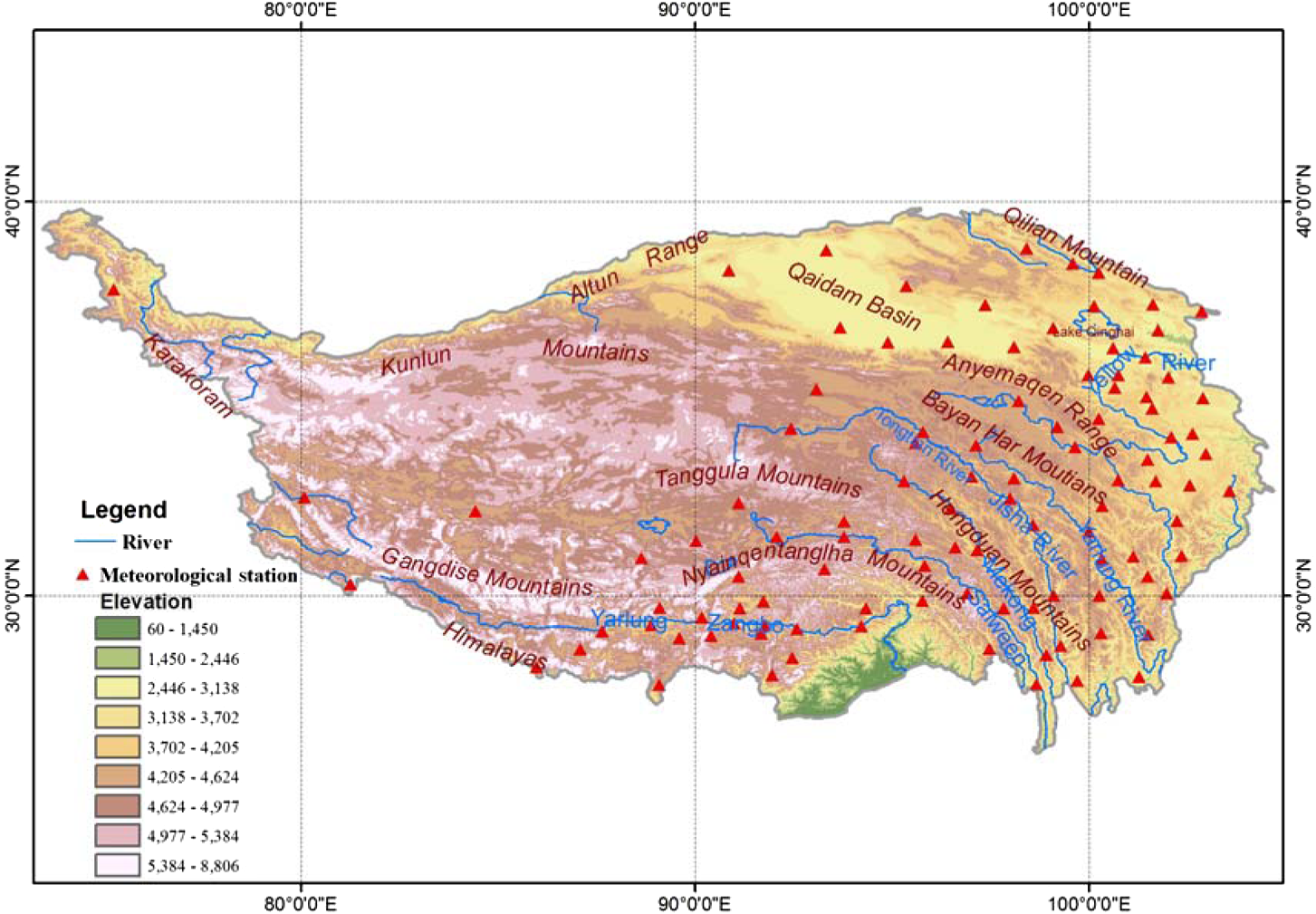
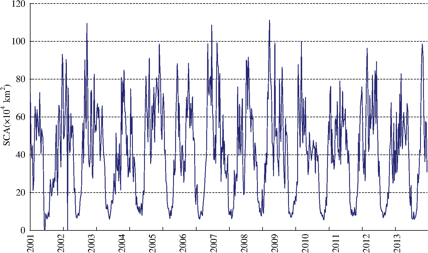
1.IntroductionSnow is an important component of the cryosphere with the largest seasonal variation in spatial extent. Its accumulation and rapid melt are two of the most dramatically seasonal and environmental changes of any kind on the Earth’s surface.1 Snow cover is largely controlled by atmospheric conditions. Snow cover anomalies may in turn potentially affect the large-scale atmospheric circulation by changing heat and moisture fluxes. More importantly, snow cover has the highest albedo of any naturally occurring surface on Earth2 and the variations in snow cover are significant indicators of climate changes.3,4 Snow-covered area (SCA) is one of the important parameters for studying both hydrology and climatology5 and the variability in terrestrial SCA has a significant influence on water and energy cycles, as well as socioeconomic and environmental consequences. Therefore, the study of snow cover trends is essential for understanding regional climate change and managing water resources.6 Over 49% of the Northern Hemisphere (NH) is covered by snow in winter. Seasonally, the area covered by snow in the NH ranges from a mean maximum in January of to a mean minimum in August of .7,8 Compared with other regions in the midlatitudes, seasonal snow cover over the TP is a unique feature in global snow maps9 and is a vital fresh water source in western China and the Himalayan regions. The largest rivers in Asia, such as the Brahmaputra (Yarlung Zangbo), Salween, Mekong, Yangtze River, and Yellow River, have their headwaters there.10 In addition, snow cover is also a significant indicator of climate condition in the TP and its surrounding areas. Previous studies showed that winter snow cover over the TP has a strong link with general circulation and monsoon systems over eastern and southern Asia during spring and summer.11,12 Snow cover variability in the TP has also responded to global warming, making it an important element in regional climate studies.13 Recent study shows that the most persistent snow cover is located in the southern and western edges of the TP within large mountain ridges and the duration for snow persistence varies at different elevation ranges and generally becomes longer with increases in the terrain elevation.9 The study on snow cover dynamics of the four typical lake basins from 2001 to 2010 in the TP based on the moderate-resolution imaging spectrometer (MODIS) snow cover products shows that there is no obvious trend of snow cover change in the examined period.14 The study in Nam Co Basin in the central TP also indicates that an alternating pattern of monsoon and autumn snow cover exits in the western part of the basin, which corresponds to the biennial character of the variations of the Indian monsoon. Areas with permanent snow cover and areas that were snow free are both found to be relatively stable.15 In the previous studies, scientists paid more attention to snow cover variations in the TP using various satellite derived data and association with climate anomalies (such as rainfall) in China and the surrounding areas. In contrast, there are a few studies on the comparison between temporal variations of snow cover from satellite data and in situ observation data, or in situ observation data used for validation and comparison of satellite data are too limited to adequately describe the overall snow cover variations on the TP. Therefore, in this study, the temporal variations of snow cover over the TP from 2001 to 2013 are examined in detail by using MODIS snow products (MOD10A2), followed by the analysis of the spatial distributions of snow cover over the TP; interannual variations of snow cover from MODIS snow products are then compared with ground-based observation data from 98 meteorological stations. 2.Study AreaTibetan Plateau (TP) is the highest and most extensive highland on the world with an average elevation of over 4000 m. Located in southwestern China and often called “the roof of the world,” the TP exerts a great influence on regional and global climate through thermal and mechanical forcing mechanisms. Its global significance does not lie in its physical parameters, but more importantly in the recognition that the plateau constitutes a significant forcing factor on the intensity of the Asian monsoons. The TP has the largest cryospheric extent outside the polar region. Snow cover can exit during all seasons over the high altitudes and its seasonal variation is the most rapidly changing surface feature on the TP. Since the TP is a large scale geographic location situated in the midlatitudes of Asia, there are many different scopes and boundaries for the TP in terms of the different contexts of the study requirements and data limitations. Some have defined the TP based on the elevation above 2000 m asl (above sea level)9,16,17 or above 2500 m asl;18,19 others just used administrative boundaries in western China, including the Tibet Autonomous Region (TAR), Qinghai province, and the whole or parts of Sichuan and Yunnan provinces.20,21 In this study, we use the boundary defined on the basis of principles taking into account the geomorphic characters as the main rule and also considering the integrity of the plateau.22 According to this scope definition, the TP within China starts from the Pamirs in the west and reaches to the Hengduan Mountains in the east with a length of 2,945 km from west to east and longitudes from 73°18′52″E to 104°46′59″E, and extends from the Himalayans in the south to Kunlun Mountain in the north with 532 km from south to north and latitudes from 26°00′12″N to 39°46′50″N, covering an area of . Administratively in China, it includes Tibet Autonomous Region, Qinghai Province, western Sichuan Province, northern Yunnan Province, and the western edge of Gansu and southern edge of Xinjiang Provinces. The geographic location and terrain characteristics of the TP are shown in Fig. 1. 3.Data3.1.MODIS DataObservation from space by satellite is the only way to obtain surface features such as snow cover at a regional to global level. In recent years, with the progress in satellite technology and algorithm development, many snow cover products are available based on remotely sensed observations. Of these, snow cover products derived from the MODIS based on visible and infrared bands are most widely used for large-scale snow cover detection and climate related researches,23 which is available since March 2000 and developed using a fully automated algorithm with a 500-m spatial resolution, cloud detection, and frequent coverage. NASA provides a hierarchy of snow products based on MODIS observations to satisfy the needs of a variety of users. MODIS 8-day composite snow product (MOD10A2) is widely used for snow cover variations in many regions, particularly at high latitudes and in mountainous regions where conventional surface observation is limited or frequent cloud cover limits the number of days available for satellite observations. Liang et al. indicated that the overall accuracy of the MODIS/Terra daily snow cover mapping algorithm in clear sky conditions is high at 98.5% and ranges from 77.8% to 100% in the northern Xinjiang area, China.24 In all weather conditions, the snow agreement of the MODIS/Terra daily product is only 34% to 50%, while it is up to 80% to 90% for the Terra 8-day product.25 Pu et al. evaluated the accuracy of the MODIS/Terra high-resolution snow cover data by comparing the data with in situ snow observations over the TP (Ref. 9) and found that the overall accuracy of MODIS snow data is about 90%. In this study, MODIS 8-day composite snow cover products from Terra (MOD10A2) are used to describe the recent spatial distribution and temporal variations of snow cover on the TP, since it has the highest spatial resolution and the least cloud contamination. The study area includes 13 tiles of MOD10A2 for each 8–day period. All MOD10A2 data were obtained from NASA Distributed Active Archive Center (DAAC) at National Snow and Ice Center ( http://nsidc.org/). The data mosaicking, projection transformation from the sinusoidal to the geographic, and data format conversion from HDF to GeoTIFF were implemented using MODIS Reproject Tool (MRT). 3.2.In Situ DataAt present, there are 105 meteorological stations available in the TP operated by the China Meteorological Administration (CMA). Most stations are situated in the inhabited, lower-altitude river valleys in the south and east, while there are no or very few ground-based observation stations located in the northwest and west. Due to complex terrain, extreme environmental conditions, the large extent and rapid seasonal variations of snow cover on the TP, the ground observation of snow cover from current stations has difficulty capturing the spatial distribution and temporal variation of snow cover. However, conventional in situ measurements at meteorological stations are the only way to provide good and long-term snow observations such as SCD, snow depth, and density in a certain area, and are vital ground controls for validating remotely sensed estimations of snow cover and snow depth. The SCD are manually measured on a daily basis in the TP and defined as the number of days with snow cover at meteorological observation sites. All SCD data used in this study are obtained from the China Meteorological Information Center, CMA and Tibet Meteorological Information Center, and Tibet Meteorological Bureau. All data quality was manually well checked and verified. Since there are missing data in seven stations from 2001 to 2011, SCD data from 98 meteorological stations are used for snow cover comparison between MODIS and in situ observations. Figure 1 shows the geographic distribution of these meteorological stations. 4.Results4.1.Temporal Variations of Snow Cover from MODIS4.1.1.Eight-day composite snow cover changesFigure 2 shows the time series of SCA changes from January 2001 to December 2013 over the TP using MOD10A2 products. The general patterns present a great seasonal variation of snow cover with a large area in the 8-day composites during winter and spring and a small area in the 8-day composites during summer. The maximum SCA for 8-day composites occurs from October 31 to November 7 in 2008 with an area of and 44.32% of the total TP area, followed by November 9 to 16 in 2002 and December 11 to 18 in 2006 with around 43% of the total TP area, whereas the minimum SCA is found in an 8-day composite MODIS image from August 13 to 20 in 2010 with only and 2.20% of the total TP area, followed by July 28 to August 4 in 2013 with (2.32%). Then SCA in 8-day composites from August 5 to 12 both in 2010 and 2003 and July 4 to 11 in 2013 is also around and 2.37% of the total TP area. If an SCA above 25% of the TP area in 8-day composites is used as a threshold for more snow cover, all of these occur from October to May, with the top three months in autumn and spring instead of the winter months. In detail, the most frequent months for snow cover above 25% are November with 23 times, the second is March with 21 times, followed October with 19 times, and the least frequency happens in May with seven times. Although based on the threshold for less snow cover, less than 5% of the TP area, the most frequent months are July with 51 times, followed by August with 32 times, and the least frequency occurs in September with six times (Table 1). Overall, mainly affected by atmospheric circulations and its seasonal variations over the TP, the larger snow cover extent in an 8-day period is more frequent in November and March during months of the transition seasons and the least snow cover extent in an 8-day composite occurs in July. Table 1The frequencies of SCA above 25% and below 5% of the TP area in MOD10A2 from 2001 to 2013.
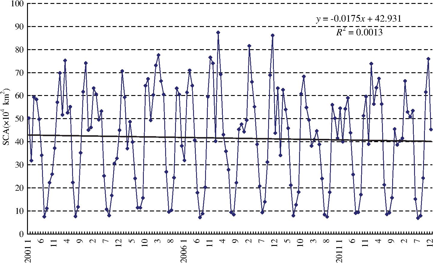
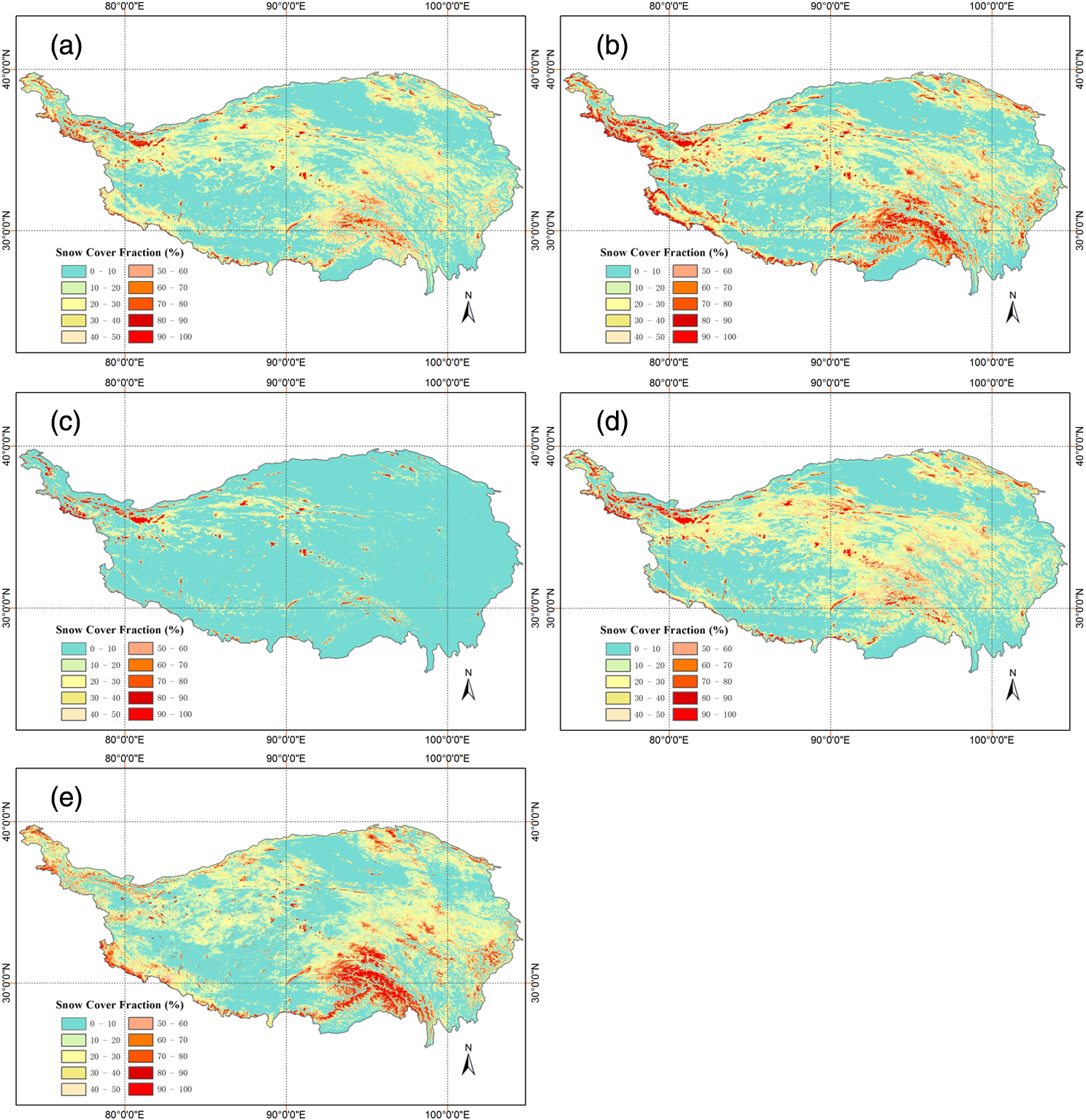
In addition to prominent seasonal cycles of snow cover with a larger extent in 8-day composites in autumn, winter, and spring and a smaller extent in summer, the linear trend analysis for MODIS 8-day composite products indicates that there is no obvious interannual change trend in SCA on the TP over the past 13 years and general snow cover extent remains a relatively stable. 4.1.2.Monthly changesThe monthly SCA is shown in Fig. 3, indicating that the minimum is reached in July in most years followed by August, while with an increase in SCA from September, the maximum is reached in November or March in most years from 2001 to 2013. The increasing trend from December to February in the following years is not obviously clear, although the SCA remains relatively high in these three winter months due to the early snow accumulation and low temperatures, which are very favorable for snow cover. The monthly SCA from 2001 to 2013 also shows that there is a slightly declining trend in SCA from 2001 to 2013, especially in November 2008 the decrease in SCA is more obvious but statistically insignificant. As described above, in addition to the strong seasonal variations, the SCA on the TP over the last 13 years remains relatively stable. The monthly mean SCA from 2001 to 2013 in Fig. 4 shows that the mean minimum SCA occurs in July with , which is only 3.49% of the total TP area, followed by August with and 4.00% of the TP area. The increasing trend of SCA is rapid from September to November and the second monthly largest extent of snow cover is reached in November, which is next to March (to ) in spring. In three months of winter, the increase of SCA is not so much, but due to the early snow accumulation and favorable low temperatures, the SCA maintains a relatively high status with above . Along with a gradually increase in temperature after March, the SCA decreases due to melting. 4.1.3.Annual changesThe annual mean SCA for the TP is shown in Fig. 5. The average annual mean SCA from 2001 to 2013 is , which is 16.72% of the total TP area. Thus, for the TP, the SCA of or 17% of the TP area covered by snow at an annual mean level can be considered as a snow cover indicator for a normal year. Figure 5 shows that 2002, 2005, and 2008 are snowy years with 46.92, 47.84, and , and 18.70%, 19.07%, and 18.76% of the total TP area, respectively. Snow cover extent in these three years is larger by 5 to than the average from 2001 to 2013. In contrast, the SCA for 2010 is the least with and 14% of the TP area, followed by 2001 and 2003 with 15% of the total TP area. As another less-snow year, the SCA in 2007 is (15.85%), which is lower by than the average SCA from 2001 to 2013. In other years, the SCA ranges from 15.96% to 17.90% of the study area and the differences in SCA from 13 years’ average are lower than , presenting these years as normal for snow cover extent. The standard deviation of SCA from 2001 to 2013 is and the average absolute error is , ranging from 0.09 to . The relative error ranges from to 14.09%. Therefore, interannual differences and variations of SCA over the TP from 2000 to 2013 are not significant. As shown in Fig. 5, a very slight declining trend exists from 2001 to 2013 and the linear equation is (), which means it is not statistically significant. At a seasonal level, the maximum SCA is reached in spring with and 22% of the total TP area and the second is in winter with (21%), followed by autumn with (18%). The minimum occurs in summer with only 6% of the total TP area. The main patterns of SCA seasonal changes from March 2001 to December 2013 are that there is a slight decreasing trend in SCA during the spring and winter and a more obvious decrease at 0.05 level of significance during the summer (figure not shown here), while an increasing trend in the SCA is found in autumn, which is not statistically significant based on the linear trend analysis. 4.2.Spatial Distributions of Snow Cover from MODIS Data4.2.1.Annual snow cover distributionThe spatial distribution of snow cover on the TP is shown in Fig. 6 using the snow cover fraction (SCF) derived from MOD10A2. Owing to high topography and complex terrain in combination with the atmospheric circulation, the spatial distribution of snow cover represented by the annual mean SCF from 2001 to 2013 over the TP, as shown in Fig. 6(a), is spatially very uneven. Overall, snow cover is rich and its duration is long with more permanent snow in the high mountains while snow cover and duration are limited in the vast interior of the TP except for some high mountains. In detail, there are two highest snow cover concentrated areas in the TP. One is Nyainqentanglha Mountain ranges and the surrounding high mountains in the southeastern TAR; another is the west Himalayans, Pamirs, and Karakoram Mountains to the western Kunlun Mountains. In addition to these two regions, more areas covered by snow are the Himalayan regions in the south and Kunlun Mountain in the north due to favorable high terrain conditions and low temperatures for snow accumulation. The largest area and the longest duration of snow cover in the interior of the TP occurs in Tanggula, Animaqing, Bayan Har, Hengduan, and Qilian Mountain ranges, although snow cover in the vast interior of the TP is limited. Snow cover in Qaidam Basin located in the northern TP and the river valleys of southern TP is very rare and the duration is days. Moreover, the snow cover in wide areas in the north of Gangdise Mountain, Qinghai Lake valley, and east regions of Mt. Animaqing is also very small. 4.2.2.Seasonal snow cover distributionThe seasonal snow cover distribution is further analyzed on the basis of seasonal average SCF over the TP from 2001 to 2013, as shown in Figs. 6(b)–6(e). As for the TP, spring is the most snow-covered season and the area of accounts for 12% of the total TP area. During this season, as shown in Fig. 6(b), the widespread snow cover is distributed in the Nyainqentanglha Mountains, Himalayas, and Karakoram in the northwest, the Kunlun and Altun Mountain ranges in the north, and the eastern plateau and Qilan Mountains in the northeast, whereas the region where the SCF is is mainly situated in Qaidam Basin, the southern valley of Lake Qinghai, the Yarlung Zangbo River valley, and the broad region in the north of the Gangdise Mountains, which is in accord with the annual mean distribution of snow cover over the TP. In summer, as shown in Fig. 6(c), the TP is least covered by snow and the area of SCF above 50% only accounts for 2% of the TP area. Since it is rainy season for the TP and the temperature is above 0°C, there is no snow cover in most areas on the TP except for some high mountain ridges where the temperature is lower than 0°C. Relatively speaking, more snow cover can be found at the higher latitudes in the northern high mountain ridges such as Karakoram, Kunlun, and Qilan Mountains compared to the lower-latitude mountain ridges such as the Nyainqentanglha Mountains and Himalayas. In autumn, the increase of snow cover over the TP represented by the SCF is obvious and the area of SCF above 50% occupies 7% of the total TP area. In addition to the apparent increase of snow cover in the high mountains such as the Nyainqentanglha, Karakoram, Kunlun, Tanggula, and Qilan, the apparent feature of the snow cover distribution in autumn compared to other seasons is that the increase of snow cover and SCF in the eastern TP, especially around Tanggula Mountain and broad regions where Bayan Har and Anyemaqen Mountain ranges are located, are significant, as shown in Fig. 6(d). The increase of snow cover and SCF is more obvious in the northern, central, and eastern TP. The location of SCF below 10% is similar to that in spring or the annual average. In winter, the snow cover extent over the TP is second only to the spring. The area of is 11% of the TP area, which is slightly smaller than the 12% of spring. The main characteristics of snow cover distribution in winter are that due to the decrease in temperature in the whole TP, particularly at lower latitudes compared to the previous season, which is very favorable for snow accumulation and maintenance, the increase in snow cover in the southeastern TP such as the Nyainqentanglha Mountain ranges and surrounding area is the most significant, followed by the Bayan Har and Anyemaqen Mountain ranges and surrounding areas. On the other hand, an increase in the snow cover extent in the west Himalayas is more obvious. However, the increase in the snow cover extent in the northwest and north of the TP is not apparent, as shown in Fig. 6(e). The location where the SCF is lower than 10% is in agreement with other seasons like spring, autumn, and the annual average. These spatial distributions of snow cover on the TP above are controlled by a combination of spatially and temporally variable atmospheric forcing conditions and how those conditions interact with relatively static local topography and vegetation distributions. Snowfall is a solid form of precipitation and the only material source of snow cover. There is no snow cover on the surface without snowfall. Snow cover is also very sensitive to temperature. Higher temperature will cause precipitation falling as rain instead of snow or will make terrestrial snow cover melt and make difficulty to form snow cover on the ground. The increase in temperature will lead to a shortening of the duration of the snow cover and is not favorable to the maintenance of the snow cover. The high topography of the TP is also an important condition for the spatial distribution of snow cover. At the higher altitude regions, air temperature is lower and precipitation is more, which is more favorable for the formation and maintenance of snow cover. This is why the most persistent snow cover is located at the regions where the elevation is above 6000 m, whereas the lower latitudes and elevations, because of higher temperatures, are not conducive to snowfall and snow accumulation and there is no snow covered in many places. In the TP, the high mountains and low lands are the most consistent with more and less snow cover distributions.26 4.3.Snow Cover Comparison Between MODIS and In Situ DataThe annual mean SCD over the TP from 2001 to 2011 is further studied using ground-based observation data from 98 meteorological stations with nonmissing data to evaluate the accuracy of the temporal variations of snow cover from MODIS snow data products (MOD10A2). As illustrated by the MODIS snow cover data above, the spatial variability of SCD on the TP is remarkable from the low altitudes to the high mountain regions. In some high-altitude places such as Qingshuihe, Chali, Shiqu, Whshaoling, and Dari stations located in the interior of the TP, the annual mean SCD reaches above 100 days, and the maximum SCD on the TP is found at Qingshuihe station with a total of 145 days. In contrast, SCD in Batang, Muli, and Gongshan stations in the southeastern TP and Lhatse, Shigatse stations located in the middle regions of the Yarlung Zangbo valley, is less than 3 days. Therefore, the averaged annual mean SCD on the TP is relatively short with 31 days. The slightly decreasing trends in the SCD are found from 2001 to 2011, but this is not statistically significant. In detail, the SCD is in increase from 2001 to 2008 and is above or equal to the average from 2001 to 2011 except for 2007 which has only 26.5 days. The decrease in SCD is more obvious during the period from 2008 to 2011, with less than the average from 2001 to 2011 for the most of the years. Particularly, the SCD in 2010 is 21.5 days which is lower by 9.5 days than the average, which is the minimum value from 2001 to 2011 at an annual level. Compared to 2010, there is a small increasing trend in the SCD in 2011, reaching to 28.8 days, but it is still lower than the average from 2001 to 2011. As shown in Fig. 7, it is clearly visible that 2002, 2005, and 2008 are relatively snowy years, and 2001, 2003, 2007, and 2010 are less-snow years both on the basis of the SCD and SCA. It should be noticed that since all these meteorological stations are located in relatively lower elevations and valleys, the resulting SCD should be treated as the lower end of the SCD for the entire TP. However, the interannual change patterns mapped by those stations should be representative of the SCD change for the entire TP. As shown in Fig. 7, the interannual variations of snow cover on the TP both from ground-based stations using the SCD and from MOD10A2 using the SCA are very consistent, showing that there is a slight decreasing trend from 2001 to 2011 in general, but this trend is not statistically significant. The snow cover fluctuation in different years is also the same, characterized by an increase of snow cover from 2001 to 2008 and a more obvious decline after that. In particular, both the SCD and SCA reach the minimum in 2010 and the maximum in 2008. It is also evident on the basis of SCD and SCA that 2002, 2005, and 2008 are snowy years and 2001, 2003, 2007, and 2010 are less-snow years, respectively. Likewise, the linear regression analysis shows that the correlation coefficient between the MODIS observed SCA and the ground measured SCD is 0.80 (), indicating that there is a statistically significant correlation between the SCA and SCD. Although the TP is characterized by extensive high mountains, complex terrains, and strong variations of snow cover on the spatial and temporal scales, it is obvious that the MODIS snow cover product (MOD10A2) has very high accuracy, is an effective way to spatially and temporally monitor snow cover variations over the TP, and can play an important role in snow-related disaster monitoring and mitigation as well as compensate for the response to snow caused disasters by sparse ground-based observed stations. 5.Conclusions
AcknowledgmentsThis work is supported by the China Special Fund for Meteorological Research in the Public Interest (GYHY201206040, GYHY201306054). MODIS snow cover products were obtained from the NASA Distributed Active Archive Center (DAAC) at the National Snow and Ice Center. Snow observation data were provided by China Meteorological Information Center, China Meteorological Administration, and Tibet Meteorological Information Center, Tibet Meteorological Bureau. The authors especially thank the anonymous reviewers and the editor for their insightful comments and suggestions that helped to improve the paper. ReferencesD. S. GutzlerR. D. Rosen,
“Interannual variability of wintertime snow cover across the Northern Hemisphere,”
J. Clim., 5
(12), 1441
–1447
(1992). http://dx.doi.org/10.1175/1520-0442(1992)005<1441:IVOWSC>2.0.CO;2 JLCLEL 0894-8755 Google Scholar
T. H. Painteret al.,
“Impact of disturbed desert soils on duration of mountain snow cover,”
Geophys. Res. Lett., 34
(12), 1
–6
(2007). http://dx.doi.org/10.1029/2007GL030284 GPRLAJ 0094-8276 Google Scholar
P. Y. Groismanet al.,
“Changes of snow cover, temperature, and radiative heat balance over the Northern Hemisphere,”
J. Clim., 7
(11), 1633
–1656
(1994). http://dx.doi.org/10.1175/1520-0442(1994)007<1633:COSCTA>2.0.CO;2 JLCLEL 0894-8755 Google Scholar
M. ValtP. Cianfarra,
“Recent snow cover variability in the Italian Alps,”
Cold Regions Sci. Technol., 64
(2), 146
–157
(2010). http://dx.doi.org/10.1016/j.coldregions.2010.08.008 CRSTDL 0165-232X Google Scholar
K. A. Dressleret al.,
“Evaluation of gridded snow water equivalent and satellite snow cover products,”
Hydrol. Process., 20
(4), 673
–688
(2006). http://dx.doi.org/10.1002/(ISSN)1099-1085 HYPRE3 1099-1085 Google Scholar
M. A. Wulderet al.,
“Snow cover variability across central Canada (1978–2002) derived from satellite passive microwave data,”
Clim. Change, 82
(1), 113
–130
(2007). http://dx.doi.org/10.1007/s10584-006-9148-9 CLCHDX 0165-0009 Google Scholar
D. K. Hall,
“Assessment of polar climate change using satellite technology,”
Rev. Geophys., 26
(1), 26
–39
(1988). http://dx.doi.org/10.1029/RG026i001p00026 REGEEP 8755-1209 Google Scholar
D. A. RobinsonK. F. DeweyR. R. Heim,
“Global snow cover monitoring—an update,”
Bull. Am. Meteorol. Soc., 74
(9), 1689
–1696
(1993). http://dx.doi.org/10.1175/1520-0477(1993)074<1689:GSCMAU>2.0.CO;2 BAMIAT 0003-0007 Google Scholar
Z. PuL. XuV. V. Salomonson,
“MODIS/Terra observed seasonal variations of snow cover over the Tibetan Plateau,”
Geophys. Res. Lett., 34
(6), L06706
(2007). http://dx.doi.org/10.1029/2007GL029262 GPRLAJ 0094-8276 Google Scholar
W. W. Immerzeelet al.,
“Large-scale monitoring of snow cover and runoff simulation in Himalayan river basins using remote sensing,”
Remote Sens. Environ., 113
(1), 40
–49
(2009). http://dx.doi.org/10.1016/j.rse.2008.08.010 RSEEA7 0034-4257 Google Scholar
R. R. Dickson,
“Eurasian snow cover versus Indian monsoon rainfall—an extension of the Hahn-Shukla results,”
J. Appl. Meteorol., 23
(1), 171
–173
(1984). http://dx.doi.org/10.1175/1520-0450(1984)023<0171:ESCVIM>2.0.CO;2 JAMOAX 0894-8763 Google Scholar
S. Yang,
“ENSO-snow-monsoon associations and seasonal-interannual predictions,”
Int. J. Climatol., 16
(2), 2038
–2051
(1996). http://dx.doi.org/10.1002/(SICI)1097-0088(199602)16:2<125::AID-JOC999>3.0.CO;2-V CLDYEM 0930-7575 Google Scholar
D. QinS. LiuP. Li,
“Snow cover distribution, variability and response to climate change in western China,”
J. Clim., 19
(9), 1820
–1833
(2006). http://dx.doi.org/10.1175/JCLI3694.1 JLCLEL 0894-8755 Google Scholar
G. Zhanget al.,
“Snow cover dynamics of four lake basins over Tibetan Plateau using time series MODIS data (2001–2010),”
Water Resour. Res., 48
(10), W10529
(2012). http://dx.doi.org/10.1029/2012WR011971 WRERAQ 0043-1397 Google Scholar
J. Kropaceket al.,
“Temporal and spatial aspects of snow distribution in the Nam Co Basin on the Tibetan Plateau from MODIS data,”
Remote Sens., 2
(12), 2700
–2712
(2010). http://dx.doi.org/10.3390/rs2122700 17LUAF 2072-4292 Google Scholar
L. Ma,
“The temporal-spatial characteristics of snow cover over the Qinghai-Tibetan Plateau in recent 50 years and its relationships with atmospheric circulation factors [in Chinese],”
Graduate School,
(2008). Google Scholar
W. W. ImmerzeelL. P. H. van BeekM. F. P. Bierkens,
“Climate change will affect the Asian water towers,”
Science, 328
(5984), 1382
–1385
(2010). http://dx.doi.org/10.1126/science.1183188 SCIEAS 0036-8075 Google Scholar
L. XuD. LiZ. Hu,
“Relationship between the snow cover day and monsoon index in Tibetan Plateau [in Chinese],”
Plateau Meteorol., 29
(5), 1093
–1101
(2010). 1000-0534 Google Scholar
G. Zhanget al.,
“Increased mass over the Tibetan Plateau: from lakes or glaciers?,”
Geophys. Res. Lett., 40
(10), 2125
–2130
(2013). http://dx.doi.org/10.1002/grl.v40.10 GPRLAJ 0094-8276 Google Scholar
R. Gaoet al.,
“The abrupt changing characteristics of snow cover and seasonal freezing-thawing layer in the Tibetan Plateau and their impact on summer precipitation in China [in Chinese],”
J. Glaciol. Geocryol., 32
(3), 469
–474
(2010). Google Scholar
J. Gaoet al.,
“Spatiotemporal distribution of snow in eastern Tibet and the response to climate change,”
Remote Sens. Environ., 121 1
–9
(2012). http://dx.doi.org/10.1016/j.rse.2012.01.006 RSEEA7 0034-4257 Google Scholar
Y. ZhangB. LiD. Zheng,
“A discussion on the boundary and area of the Tibetan Plateau in China [in Chinese],”
Geogr. Res., 21
(1), 1
–8
(2002). 1745-5863 Google Scholar
A. Freiet al.,
“A review of global satellite-derived snow products,”
J. Adv. Space Res., 50
(8), 1007
–1029
(2012). http://dx.doi.org/10.1016/j.asr.2011.12.021 ASRSDW 0273-1177 Google Scholar
T. Lianget al.,
“Application of MODIS data on snow cover monitoring in pastoral area: a case study in the Northern Xinjiang, China,”
Remote Sens. Environ., 112
(4), 1514
–1526
(2008). http://dx.doi.org/10.1016/j.rse.2007.06.001 RSEEA7 0034-4257 Google Scholar
X. ZhouH. XieJ. M. H. Hendrickx,
“Statistical evaluation of remotely sensed snow-cover products with constraints from streamflow and SNOTEL measurements,”
Remote Sens. Environ., 94
(2), 214
–231
(2005). http://dx.doi.org/10.1016/j.rse.2004.10.007 RSEEA7 0034-4257 Google Scholar
P. LiD. Mi,
“Distribution of snow cover in China [in Chinese],”
J. Glaciol. Geocryol., 5
(4), 12
–18
(1983). Google Scholar
W. Wanget al.,
“Early warning of snow-caused disasters in pastoral areas on Tibetan Plateau,”
Nat. Hazards Earth Syst. Sci., 13
(6), 1411
–1425
(2013). http://dx.doi.org/10.5194/nhess-13-1411-2013 1561-8633 Google Scholar
BiographyChu Duo received his BS degree in meteorology from the Nanjing Institute of Meteorology in 1990 and his PhD degree in physical geography from the Graduate School of Chinese Academy of Sciences in 2003. His current research interests include snow cover remote sensing, surface parameters retrieval, and related climate change in the Tibetan Plateau. |
||||||||||||||||||||||||||||||||||||||||