
|
|
1.IntroductionSnow is an important, though highly variable, earth surface cover.1 In terms of spatial extent, snow cover is the second largest component of the cryosphere after seasonally frozen ground (), with a mean maximum areal extent of . Approximately 98% of snow cover is located in the Northern Hemisphere, where temporal variability is dominated by the seasonal cycle.2 Because of its high albedo, snow is a significant factor in determining the radiation balance, which has implications for global climate studies.3 Mid-latitude alpine snow cover and its subsequent melt can dominate the local and/or regional climate and hydrological process; thus, there has been an increased focus on snow cover in the world’s mountainous regions. Moreover, the extent and dynamics of snow and ice cover affect many hydrological, physical, chemical, and biological processes.4 Accurate monitoring of snow cover extent, snow water equivalent (SWE), and other properties of snow is pivotal in research areas in the fields of hydrology, climate change, and human-environment interaction. Satellites are well suited to the measurement of snow parameters, as they provide multiplatform, multispectrum, and multiscale observations. Snow is a unique ecosystem with its own annual and interannual variations. It contributes to resources and activities, such as water supply, hydropower navigation, aqua-products, recreation, flood mitigation, water storage, soil conservation, pollutant purification, biodiversity, tourism, and entertainment. In China, snow is an important fresh water resource; annual snowfall recharge is more than six times the amount of glacial meltwater and is approximately equal to 43% of the annual dynamic reserves of groundwater, as well as 1.6 times the storage of freshwater lakes.5 In the mid-latitude arid and semiarid mountain regions of China, more than 75% of river water is from snowmelt runoff.6 Snow cover over the Tibetan Plateau is a vital water source in western China; the headwaters of many large rivers (e.g., Yangtze River, Yellow River) originate there. Additionally, industry and agriculture are influenced and restricted by snow cover. Grasslands and pastoral areas have suffered from heavy snow disasters. A strong correlation has been discovered between snow over the Tibetan Plateau and floods in the south and east of China. For instance, flooding of the Yangtze River in 1998 was linked to heavy snow cover over the Tibetan Plateau.7 In recent years, there has been a high frequency of snow disasters in the southern parts of China, indicating the importance of monitoring snow distribution and variations using satellite remote sensing data. 2.Development of Snow Remote Sensing in ChinaSince the establishment of snow and glacier expeditions in 1958, supported by the Chinese Academy of Sciences (CAS), great progress has been made in cryosphere research for China. In 1978, under the advocacy of academician Yafeng Shi, the Lanzhou Institute of Glaciology and Cryopedology in the CAS organized a glacier remote sensing group. In 1983, it was reorganized as the Laboratory of Remote Sensing Applications in Cold Regions and is currently China’s leader in snow remote sensing research. The forecasting of snowmelt runoff is the primary research focus of snow remote sensing in China due to the associated economic impacts. For example, researchers at the Lanzhou Institute of Glaciology and Cryopedology used data from a National Oceanic and Atmospheric Administration (NOAA)-5 high resolution radiometer to study the snow cover and snowmelt runoff in the northeast and north of China.8 Further studies occurred in the Heihe River Basin in the Qilian Mountains and in the upper stream of the Longyang Gorge in the Yellow River Basin, leading to a positive economic outcome.9–12 Recent research has focused on the relationship between climate change and mountainous snow cover and snowmelt runoff.13 In the late 1990s, under cooperation between the Chinese Meteorological Administration and the Department of Transportation, several statistical models were developed based on data from remote sensing studies of snow disasters in the pastoral areas of China.14 Recently, basic remote sensing research, especially the electromagnetic properties of glaciers and snow, has improved due to the use of spectral measurements and the selection of optimal satellite spectral wavebands from the Earth Resources Technology Satellite of China.15 Researchers at Fudan University investigated microwave scattering and thermal radiation of sea ice and snow cover using vector radiative transfer theory,16 which provides a solid basis for understanding passive microwave remote sensing of the cryosphere. Since the beginning of the CAS Knowledge Innovation Project in 1999, the field of snow remote sensing has rapidly developed. Quantitative remote sensing, cold region hydrological remote sensing, and ground synchronous experimental observations are new research areas within China. In 2008, we carried out a remote sensing and ground synchronous observation experiment in the Heihe River Basin. Results obtained from snow parameter measurements enhance the understanding of snow hydrological processes; this has a profound impact on snow remote sensing in China.17 In 2010, a Cooperative Observation Series for Snow (COSS) was designed and implemented in order to study specific research questions. To date, COSS has conducted a series of experiments in different snow pattern regions in China. In recent years, snow cover and its distribution, obtained using satellite data, have been studied extensively. This includes algorithm improvement and validation and product development supported by projects such as the basic research projects by MOST (Ministry of Science and Technology of the People’s Republic of China). These projects analyzed snow parameters at different scales in order to understand the impacts of climatic change and global warming. Aiming to summarize and integrate research results of snow remote sensing in China, the first conference of snow remote sensing convened in Lanzhou City on August 1 to 2, 2013. Five topics were discussed: snow measurement and observation, radiation transmission theory and models on snow, optical remote sensing on snow, microwave remote sensing on snow, and applications of snow remote sensing. A total of 68 scientists from 20 institutes and universities exchanged the latest research results and conclusions at this conference. This meeting, named “the snowman exchange,” will be held every 2 years in China. 3.Retrieving Snow Parameters from Remote Sensing Imagery3.1.Snow Cover AreaInitially, snow was successfully mapped by visual interpretation using ESSA-3 satellite data.18 These maps have been continually improved with the addition of new satellite data, such as the Landsat Multispectral Scanning Subsystem, the Landsat Thematic Mapper (TM), the NOAA Advanced Very High Resolution Radiometer (AVHRR), and the Moderate-Resolution Imaging Spectrometer (MODIS).19–22 Some operational regional or global snow cover binary products have also been issued and can be readily acquired.23,24 In China, there have been many studies of snow cover mapping since the 1980s. Based on field measurements of snow and ice reflectance values, Zeng et al.25 and Cao et al.26 searched the optimal bands for snow cover retrieval. Ma et al.27 utilized supervised classification (SC) of NOAA-AVHRR data to map the snow cover area in Northern Xinjiang, China. Because these methods are not automated, they can only be used for snow mapping in local regions. Using TM, AVHRR, and MODIS images, Wang28,29 assessed the accuracy of three methods: training sites’ SC, digital numbers’ statistics, and the Normalized Difference Snow Index (NDSI)—they found the NDSI method to be more accurate. With the development of sensor techniques, various snow cover data have been improved. Xiao et al.30,31 developed a snow cover product using SPOT-VEGETATION data. Yan32 developed a complex index method to map snow cover and mask cloud cover using NOAA-16 data. In addition, Li et al.33 produced a daily snow product by combining one day’s worth of multitemporal images at a spatial resolution of , based on FY-2 satellite data. In general, although there are many snow cover products developed using different methods and remote sensors, MODIS snow cover products, which are produced by the NDSI method and derived from the NASA National Snow and Ice Data Center (NSIDC), are more accurate and are widely used in China.34 The NDSI threshold, used for retrieving MODIS snow cover products, obtained from MODIS global snow cover products, was initially developed and validated in the United States, Canada, and Russia. Hao and Wang35 showed that the MODIS snow cover product underestimated snow cover in the Qilian Mountains and that the regional NDSI threshold is much less than 0.4. In addition, a common challenge is how to exclude the cloud pixels in snow cover products. To address this, a series of blending algorithms which provide daily no-cloud snow cover from MODIS data have been developed and include the following: daily Terra-Aqua/MODIS image combination,36–40 temporal deduction,41 the snow-line method (SnowL),42 and multisensor combinations.43 Hao et al.44 developed a blending algorithm which can provide daily no-cloud snow cover from MODIS data by adjusting the NDSI threshold value and combining MODIS and AMSR-E data. This method was used to produce 3-years’ (2008 to 2010) worth of daily no-cloud snow cover products of the Qinghai–Tibet Plateau. Figure 1 shows the workflow of the improved MODIS cloud removal algorithm applied to the Qinghai–Tibet Plateau on January 25, 2008. In the study, there are three steps needed to produce the snow cover products. The output from each step is the input for the next step. Moreover, by combining the previous cloud removal algorithms, Huang et al.45 generated a new daily cloud-free snow cover product using MODIS daily snow cover products (MOD10A1, MYD10A1), an AMSR-E daily SWE product, and a digital elevation model. This method is expected to play an important role in improving the accuracy of snow cover monitoring. Considering the inherent deficiency of MODIS data—that patchy snow or snow depth of below 3 cm is often missed—the improved snow products show agreement up to 91.7% with an overall accuracy of 91.9%. Figure 2 shows the MODIS daily cloud-free snow product composite of the Qinghai–Tibet Plateau, China, on February 18, 2011. Fig. 1The workflow of the improved MODIS cloud removal algorithm in the Qinghai–Tibet Plateau on January 25, 2008. First, the image fusion of MODIS Terra and Aqua snow cover products which have been improved by adjusting of NDSI. The second step deduces the cloud-covered pixel based on the one day forward and one day backward information of same pixels. Finally, blending MODIS snow cover and improved AMSR-E Snow depth data would eliminate completely remove cloud pixels (Reproduced from Ref. 44).  Fig. 2MODIS daily cloud free snow product composite process in the Qinghai–Tibet Plateau, China, on February 18, 2011. (a) is the MODIS snow cover product from Terra, (b) is the MODIS snow cover product from Aqua, (c) is the composite of Terra and Aqua snow cover product, (d) is the adjacent temporal composite, (e) is the interpolation using SnowL methods, (f) is the composite of results of (e) and AMSR-E snow water equivalent products. Each step was considered as the input of next step. (Reproduced from Ref. 45).  3.2.Fraction of Snow CoverTraditional snow cover mapping methods treat all pixels as uniform. Although the NDSI-based method has improved estimation accuracy as compared with other methods, it is still limited by the mixed pixel problem and is thus unable to meet the precision requirement for snow characteristics at local or basin scales. Thus, a more accurate snow cover fraction (SCF) map is desired over a traditional binary snow map. At present, three types of approaches have been developed for deriving the SCF: statistical regression, spectral unmixing, and machine learning. Statistical regression is the most widely used type; it establishes a unified regression model based on the relationship between the SCF and reflectance/NDSI.46–52 MODIS SCF products from the NSIDC, such as MOD10A1 for Terra and MYD10A1 for Aqua, were produced using statistical regression. In China, Jin et al. modified the parameters of the subpixel SCF model proposed by Salomonson.51 They retrieved the subpixel SCF from MODIS data using CBERS-2 CCD data as ground truth in Northeast China.53 Zhang et al.54 also established a linear relationship model between SCF and NDSI using HJ-1B data as ground truth. The precision of the linear regression using a single value of the NDSI is low, where the SCF is near 1 or 0. To solve this problem, the relationship between the SCF and multiple factors can be defined; Cao and Liu55 developed a linear relationship model between SCF, NDSI, and NDVI to improve snow detection in forests. Moreover, several different segmentation methods were also proposed to determine SCF, which were validated by using ETM+ or HJ-1B CCD/IRS images. Findings show that the product generated using the segmentation method is improved, as compared with the MOD10A1/SCF product.56–58 Additionally, Liu et al.59 proposed a nonlinear regression model to retrieve the SCF based on the NDSI. Tang et al.60 considered different land cover types and developed a subpixel snow mapping algorithm for the Qinghai–Tibet Plateau using MODIS data and linear regression. The statistical regression model is simple and easy to operate. However, this method is limited and difficult to apply due to large differences in the model parameters, which are caused by factors such as different land cover types and regions and the physical state of the snow. Spectral unmixing is another widely used method, which creates a hybrid, simulated spectrum and estimates the mixed reflectance for each pixel in each frequency band. The reflectance of each mixed pixel is then calculated as a function of the spectral endmember.61–67 Linear spectral mixture analysis is the most commonly used spectral unmixing method, which regards the observed reflectance as a linear combination of reflectance from certain surface constituents. Liang et al.68 used a linear mixture spectrum disassembling method to study the snow coverage rate and spatial classification for four NOAA satellite images under sunny conditions during two snow disasters in China from 1996 to 1997. Pei et al.69 used a linear spectrum mixing model to extract the SCF in the northern Xinjiang Region from MODIS imagery. Chen et al.70 extracted snow area at a subpixel scale using a linear spectral mixture model from MOD02HKM imagery. Zhu et al.71 retrieved the subpixel snow-covered area for the Qinghai–Tibet Plateau from MODIS data by employing a linear spectral mixture method based on multiple-endmember spectral analysis. Zhang72 tested one linear mixture model (LMM) and three different nonlinear subpixel analysis methods: fuzzy c-means clustering, back-propagation neural networks, and support vector machine (SVM). They concluded that the LMM and the SVM provided the best estimates of snow cover components. Notably, Hao et al.73 validated the accuracy of four different subpixel analysis methods: linear regression, full-constrained linear mixed-pixel decomposition, sparse regression unmixing, and non-negative matrix unmixing, based on the known proportion of snow in Northern Xinjiang, China. A comparison of the above methods shows that the linear regression method has the lowest accuracy, especially when the snow proportion is less than 50%; the accuracy of the sparse regression algorithm and non-negative matrix factorization were slightly higher than the full-constrained linear mixed-pixel decomposition (Fig. 3). Better results could be obtained using other unmixing inversion algorithms; however, the computation will be very time consuming due to the large amount of remote sensing data. In general, the advantage of linear spectrum unmixing is that it can be easily modeled due to having a clear physical and scientific basis. The previous studies also confirm that the method gives a comparatively accurate estimation of snow. The main drawback of linear spectrum unmixing is the assumption that the same object in a pixel has the same spectral characteristics. However, the same object may yield different spectra; different objects can have the same spectrum. Thus, the selection of reasonable endmembers and reference spectral values can be problematic and may result in large errors. The nonlinear spectral unmixing model is generally more complex. Many of the model parameters are difficult to accurately determine, making it difficult to use in practice. In addition, the computational efficiency of the method is usually problematic for large data volumes. Fig. 3The comparison of results of fractional snow cover between in situ measurements and the results from four spectral unmixed models from the Fukang and Fuyun study areas (Reproduced from Ref. 73).  Based on intelligent computing, a machine learning approach can be used to estimate the SCF as an alternative to regression and spectral unmixing. Dobreva and Klein74,75 first investigated the applicability of three-layered feed-forward error back propagation artificial neural networks (ANN) to estimate MODIS SCF of flat areas in the Northern Hemisphere. Inspired by this, Hou and Huang76 developed a three-layer feed-forward ANN for mountainous fractional snow cover (FSC) mapping using MODIS products [reflectance at seven bands, NDSI, land surface temperature (LST), and SCF], ETM+, and auxiliary topographic (elevation, slope, and aspect) data. They designed eight experimental schemes according to the different combinations of input components. Images from three time periods were chosen to train and validate the ANN; the proposed method was tested on three different test sets (nonindependent, temporal independent, and spatial-temporal independent) at the upper reaches of the Heihe River Basin. The SCF maps, derived from Landsat ETM+ reference values, MODIS SCF (MOD10), eight ANN schemes on nonindependent Test1 and spatial-temporal independent Test4, are shown in Fig. 4. The figure illustrates that the ANN can easily incorporate auxiliary information to improve the accuracy of mountainous FSC mapping with considerable generalization. However, a machine learning-based approach requires adequate representation of the training samples, which can be difficult to achieve. Additionally, due to the massive number of pixels in remote sensing images, the training set is very large, which often leads to unstable performance. Fig. 4Snow cover fraction (SCF) maps from (a) ground-truth derived from Landsat ETM+, (b) MOD10, and (c)–(j) results derived from different artificial neural network schemes on nonindependent Test1 (Reproduced from Ref. 76).  3.3.Snow Grain SizeSnow grain size is an important parameter that can indicate snow albedo change. It is also an important input factor of many snow and climate models. Satellite remote sensing of snow is critical for monitoring snow age, pollution levels, and grain sizes over difficult-to-access mountainous regions. Fundamental to all remote sensing algorithms is the relationship between the measured reflectance and the to-be-retrieved microphysics characteristics. Over the past 20 years, many researchers have made use of remote sensing satellite images, such as TM and AVHRR, to retrieve snow grain size.77–79 Nolin and Dozier80 described a method for remotely sensing grain size from airborne visible / infrared imaging spectrometer (AVIRIS) data using the snow reflectance at 1.03 μm generated by the discrete ordinates radiative transfer (DISORT) program for a multilayered plane-parallel medium model and the wavelength of prominent ice absorption features. This method was sensitive to sensor noise and required knowledge of the solar and viewing geometries. Subsequently, a more robust algorithm81 that integrated the absorption bands near the 1.03-μm wavelength (0.96 to 1.08 μm) minimized many effects of noise on grain size retrievals. Painter et al.82,83 used a linear spectral unmixing method to map relative grain size at subpixel resolution from AVIRIS data. Then, they developed MODSCAG (MODIS snow-covered area and grain size), which maps snow and its grain size simultaneously using spectral mixture analysis coupled with a radiative transfer model. In China, there are also studies on retrieving snow grain size from remote sensing data. Hao et al.84 retrieved snow grain size using three methods applied to HYPERION data over Qilian Mountain, China. The results of the three methods were compared with the in situ data of snow grain size, which were measured synchronously as the HYPERION sensor passed over the snowpack field.85 Jiang et al.86 also validated these methods using spectrum reflection data of snow in different grain sizes measured over the Binggou Basin. However, their methods generally used either the WW (Wiscombe–Warren) or DISORT model. They assume snow particles to be an equivalent sphere; Mie scattering (MIE) scattering theory is then used to model the optical characters of a single spherical snow particle. Nevertheless, as suggested by numerous experimental studies of microphysics snow properties, the snow pack should be considered as a multiple scattering, closely packed medium consisting of snow particles with irregular shapes.87–90 Kokhanovsky et al.91,92 developed an asymptotic radiative transfer (ART) model to model the snow spectra for different snow shapes and grain sizes. It simplified the traditional radiative transfer model, but without the loss of model accuracy. Hao et al.93 developed an improved snow retrieval method using the ART model and the in situ spectral reflectance of different snow grain sizes. Finally, the method was validated using in situ snow grain size, which was used to calculate the equivalent snow grain size by the improved digital snow particle properties method. Figure 5 shows the validation results of the improved snow grain retrieval algorithm. Fig. 5Scatterplot showing the correlation between measured snow grain size and grain size derived from the asymptotic radiative transfer method (Reproduced from Ref. 93).  3.4.Microwave Remote Sensing of SnowSeasonal snow cover plays an important role in hydrological cycles and climate processes.94,95 The observations of sparse weather stations cannot meet the demand; thus, it is important to develop a retrieval method of snow depth or SWE from remote sensing data. Passive microwave remote sensing is the most efficient way to retrieve snow depth and SWE. Snow depth retrieval can be influenced by the condition of snowpacks, such as snow crystal,96–98 snow density,99,100 and vegetation.101 Inaccurate snow properties will lead to large errors in the retrieved snow depths. The global passive microwave snow depth retrieval algorithms did not consider these characteristics and overestimated snow depth in western China.101,102 Snow depth retrieval from passive microwave dates back to 1993 in China. Cao and Li103 used scanning multichannel microwave radiometer (SMMR) data to develop a snow depth retrieval algorithm for high mountains, plateaus, low mountains, hills, and basins in western China. In order to meet the demands of climate and hydrological researchers, Che et al.104 developed a snow depth time series. Che et al. modified the Chang algorithm105 and developed a relationship between the observed snow depth and passive microwave brightness temperature from SMMR and SSM/I, respectively. In this algorithm, the influence of forest on snow depth retrieval was removed by integrating the forest fraction into the algorithm. Because precipitation, cold deserts, and frozen ground have similar volume scattering with snowpack, they are initially discerned from snowpack using a decision tree.106 This long-term daily snow depth data product was obtained via the WESTDC (the Environmental and Ecological Science Data Center for West China, http://westdc.westgis.ac.cn/). The data were used to analyze the interannual variations of snow depth in China and three stable snow cover regions [Northwest, Northeast, and Qinghai-Xizang (Tibet) Plateau] from 1978 to 2007;104 updated results (2012) are shown in Fig. 6. Fig. 6Interannual variation of snow depth in China and three stable snows cover regions (Reproduced from Ref. 104).  Since 2010, the microwave radiation instrument, carried on the FY-3B satellite, has provided brightness temperature data at the same frequencies as AMSR-E. Based on these data, a statistical relationship between snow depth and brightness temperature was developed for bare soil, grassland, and forest.107 This relationship is used in the operational algorithm for developing snow depth and snow-water equivalent products at the Chinese Meteorological Administration. Because snow properties vary in both space and time, static algorithms tend to underestimate snow depth in the early snow season and overestimate in the late snow season. Therefore, a dynamic algorithm is needed to accurately monitor snow depth variation in a snow season and requires seasonal information of snow properties. In China, Che et al.104 calculated the effects on snow grain size and density due to seasonal variations and used an empirical offset to modify their respective influences. The snow depth data product (at the WESTDC) was further updated using this dynamic algorithm. It has been downloaded more than 550 times (one file contains one year of snow depth data) by 337 registered users and has been used in many fields of research, such as spatiotemporal distribution of snow cover, climate change, ecologic change, cold region water cycle, and hydrological modeling.108–110 Detailed snow information was considered in the algorithm developed by Dai et al.102 The authors investigated various properties of snow during different periods of a snow season and analyzed the seasonal snow depth and density variation based on 10 years of station data; finally, they obtained a priori snow characteristics (stratigraphy, snow grain size, density, and snow temperature) for Northwest China. The microwave emission model of layered snowpacks (MEMLS) model was used to simulate the snow brightness temperature based on the a priori snow characteristics; reference tables were then established showing the relationship between brightness temperature and snow depth. By considering detailed snow characteristics, the retrieval results were more accurate than other equivalent snow depth and snow water products. When the dynamic algorithm developed in Northwest China was applied to Northeast China, the snow depth was underestimated due to the presence of large forested areas. The attenuation due to the presence of forest, and the associated upwelling radiation, can decrease the scattering signal from snow cover, causing an underestimation of snow depth in forested areas.111–113 In order to eliminate the influence of forest on snow depth retrieval and improve retrieval accuracy in Northeast China, an optimal iterative method was used. Forest transmissivities at 18 and 36 GHz based on the microwave radiative transfer models of forest and snow were calculated, as well as snow properties measured from field experiments.114 The results indicated that the transmissivities in forested areas in Northeast China are 0.656 and 0.895 at 18 and 36 GHz, respectively. The reference tables linking brightness temperature and snow depth in forested areas were built, which allowed for the estimation of the snow depths. Topography is another factor that influences snow depth retrieval using passive microwave data. Jiang combined the Dense Media Radiative Transfer Theory and Advanced Integral Equation Model (AIEM) to simulate brightness temperatures of snowpacks.115 Interface roughness was considered in the AIEM, which was then used to simulate the reflectivity on the soil/snow interface. Since the electromagnetic wave absorption properties of water, the volume scattering of the snowpack is removed, and wet snow cannot be monitored by passive microwave. The strong absorption properties of wet snow are utilized by the synthetic aperture radar (SAR) to efficiently discern wet snow from other types of snow.116 In the mid-1990s, Li et al.117 examined the capability of snow-cover mapping with multifrequency and multipolarized SAR images from SIR-C.117 Sun et al.118 used multitemporal ENVSAT-ASAR images to characterize the seasonal variations of snow-covered landscapes in the upper reaches of the Heihe River Basin and retrieved the wet snow cover with a threshold. Wen et al.119 developed a snow depth retrieval algorithm based on ENVISAT-ASAR data by considering the microwave radiative transfer and the interaction between microwave radiation and the snow/soil interface. Moreover, the launch of interferometric SAR allowed for the mapping of snow cover using repeat pass SAR images.120 However, most of the current methods can only retrieve wet snow cover area; a method to map total snow cover area has yet to be developed. 3.5.Snow Data AssimilationSnow data assimilation provides a method to integrate all available observations related to snow variables into a land surface model to improve the estimation of variables, such as snow cover area, snow depth, and snow water equivalence. Because microwave remote sensing data can derive snow depth/SWE and optical remote sensing data can accurately obtain snow cover area, snow data assimilation usually focuses on how to assimilate microwave data on the basis of a radiative transfer model of snow and how to assimilate satellite-based snow cover area on the basis of an empirical relationship between snow cover area and snow depth. In China, the study of snow data assimilation is very limited and mainly conducted at CAREERI, CAS. With respect to snow radiance assimilation, the MEMLS has been integrated into the Chinese Land Data Assimilation System (CLDAS).121 The CLDAS is capable of assimilating passive microwave brightness temperatures (i.e., AMSR-E and SSM/I) to improve snow depth and SWE estimates on the basis of ensemble Kalman filtering (EnKF). Huang et al.122 analyzed the impacts of snow grain size and stratigraphy on snow radiance assimilation. They then developed an ensemble-based snow radiance assimilation method using an ensemble batch smoother to simultaneously characterize the SWE and soil freeze-thaw state by assimilating multifrequency active/passive microwave data.123 Che et al.124 developed a snow data assimilation scheme that directly assimilates passive microwave brightness temperature data into a snow process model. Results show that the data assimilation system can improve the estimation of snow depth in the accumulation period, but not in the ablation period. To better assimilate satellite-based snow cover products, Huang125 developed and validated a technique to assimilate daily MODIS SCF products with an ensemble Kalman filter. Applied in the Xinjiang Province, the assimilation of MODIS SCF with an ensemble Kalman filter gave reasonable SCF values and improved snow depth estimation. Li et al.126 assimilated MODIS snow cover area data and microwave snow depth data into a physically based snow model, using ensemble Kalman filtering to simulate snow distribution in regions where snow is patchy and shallow. Results show this method is applicable to other ungauged regions. 4.Experiments on Remote Sensing of SnowA series of large observational experiments for land surface processes have played an important role in understanding earth systems from an experimental perspective, particularly in cold and arid regions. For example, under the framework of the climate and cryosphere project from 2002 to 2005, the cold land processes experiment was carried out to study the terrestrial cryosphere.127 In China, scientists have realized the importance of these recent experiments in the development and innovation of remote sensing technology, development of algorithms, and validation of products. In China, experiments focusing on snow have been carried out with increasing frequency since 2007. 4.1.Hydrological Remote Sensing in Cold Regions: a Ground-Based Synchronous Observation Experiment in the Upper Reaches of the Heihe RiverThis experiment was one of three components of the Watershed Allied Telemetry Experimental Research (WATER) project. WATER was a multiscale land surface/hydrological experiment conducted in a cold and arid region in China. It was a simultaneous airborne, satellite-borne, and ground-based remote sensing experiment aiming to improve the observation ability, understanding, and predictability of hydrological and related ecological processes at a catchment scale.128 In cold regions, hydrological remote sensing and a ground-based synchronous observation experiment in the upper reaches of the Heihe River were implemented from July 2007 to December 2009. The aim of the experiment was to understand hydrological processes and enhance the level of quantitative remote sensing in cold regions. Based on airborne remote sensing and ground-based tests, satellite-based remote sensing methods were developed and improved to extract hydrological process parameters for cold regions. The experiment was carried out in three areas (Binggou watershed, Arou grassland, and Biandukou) where land cover ages differed. Quantifying snow cover and frozen soil variables and parameters was the primary goal of the experiment (Table 1). Synchronous experiments occurred in four areas of different scales: watershed, sub-basin, hydrological unit, and pixel. In these areas, dense ground synchronous observation was jointly carried out with observations of fluxes and meteorological and hydrological elements. Aviation sensors containing a microwave radiometer, a hyperspectral imagery camera, a thermal infrared imagery camera, and a multispectral CCD camera collected a wealth of visible/near infrared, thermal infrared, active and passive microwave satellite data over the experimental areas (Tables 2 and 3). Through the experiments, an air-satellite-ground-based integrated dataset was built for the upper reaches of the river, which can be used to improve and validate land surface/hydrological process models in cold regions. Table 1The ground observation items in the simultaneous observation experiment.
Table 2The information of airborne remote sensing in the simultaneous observation experiment.
Table 3The information of satellite remote sensing in the simultaneous observation experiment.
This experiment is the first remote sensing experiment in China to focus on snow and frozen soil, and it has had wide participation from snow remote sensing scientists in China. Twenty-six ground-based remote sensing sensors, with more than 100 supplementary instruments, were used to observe and monitor the land surface properties of snow and its variations. 4.2.Cooperative Observation Series for SnowThe snowfield measurement experiments were initially designed to investigate snow properties of typical snow areas in China, such as the North Xinjiang in China, Qinghai–Tibet Plateau, and the Northeast of China. The experiments are composed of a series of long-term snow surveys, primarily conducted every year, with joint collaboration from different universities and institutes. Thus, the snowfield measurement experiments were termed the COSS. The first experiment was carried out in the daytime at two snow fields, located in Fukang and Fuyun Counties of the North Xinjiang from December 1, 2010, to December 15, 2010. The purpose of this experiment was to develop retrieval methods of snow properties based on the quantitative understanding of measurements. First, blending methods of optical and passive microwave remote sensing techniques on snow were explored using multiple observations coincident in time and location. Second, the passive microwave signal responding to heterogeneous snow depth was measured, and the relationship was studied. In addition, quantitative observations of interactions between the snow optical spectrum, snow grain size, snow albedo, snow dust, and black carbon (BC) were made. As we know, optical and microwave signal responses from remote sensors are influenced by factors such as snow depth, density, wetness, crystal size and shape, and ice crusts, among others. To better understand these factors, we measured snow layer properties in snow pits, including snow depth, snow density, wetness, snow grain size, snow temperature, snow albedo, snow spectral, and snow microwave brightness temperatures. Snow samples were collected to analyze the content of snow dust and snow BC (Table 4). All of the airborne datasets described here and detailed information for data collection and processing are available online ( http://westdc.westgis.ac.cn/). Table 4Snow properties, measurement methods and objectives on Cooperative Observation Series for Snow (COSS).
In order to quantify the influence of forested areas on the estimation of snow depth, fieldwork was carried out in northeast China in January and March 2012 and in January 2013. Each time, snow transects through both forested and nonforested regions were designed, and snow properties along the transects were measured, including snow depth, snow density, grain size, temperature, and stratigraphy. 5.Utilizing Remotely Sensed Snow Data to Model Hydrological ProcessesMany efforts using various methods have been made to integrate remotely sensed snow data into hydrological processes in cold regions in China. Method 1: Remotely sensed snow data are used as input to drive the model simulation. The degree-day factor method is the most common approach to model snowmelt runoff utilizing remotely sensed snow cover data. The Snowmelt Runoff Model (SRM),129 based on the degree-day method, has been widely used in China.130–136 Utilizing an improved degree-day method, a distributed snow hydrological model was developed.137 Method 2: A snow hydrological model is derived using meteorological forcing, and the simulated snow status is adjusted or assimilated by the remotely sensed snow data. Recently, research has demonstrated that the synthesis methods could be used for improving the modeling accuracy of snow distribution. Considering the high spatial heterogeneity and complexity of snow hydrological processes, RS data were inserted into this more physically based snow model.126,138 For example, Li and Wang139 developed a physically based snow model to more accurately describe the snow distribution in regions where snow is patchy and shallow. In this model, an energy balance method and RS data were used to simulate a complete snow season. Plot-scaled observations of SWE and daily discharge were used to validate the simulated results (Fig. 7). This study demonstrated a large improvement by utilizing RS data in a physically based snow model. Fig. 7The sampling regions for snow water equivalent observation (left) and the validation of daily discharges (Reproduced from Ref. 139). 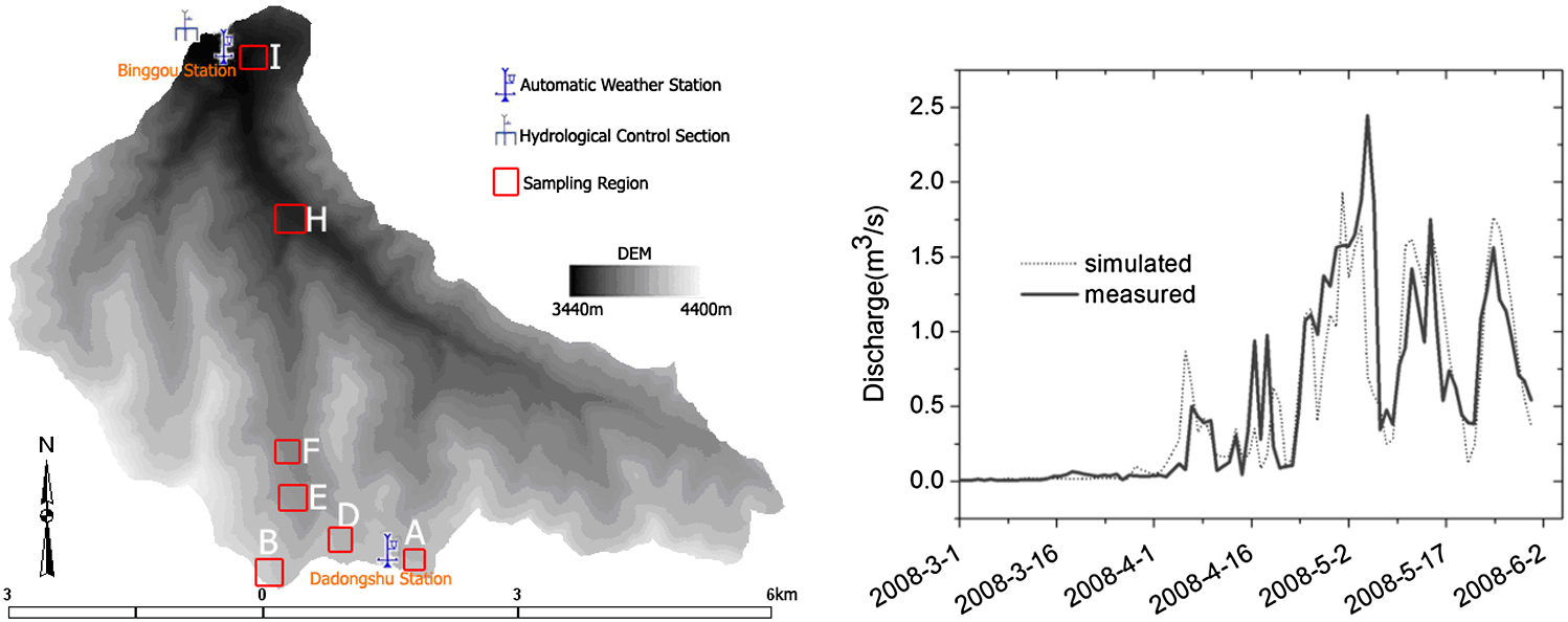 RS data play an important role in evaluating the influence of climate change on snowmelt runoff.140 In the upper basin of Heihe River in Northwestern China, Wang et al.141 analyzed the influence of climate change on snow runoff using remotely sensed snow data with cloud removal. In the study, the SRM model was used to forecast the snowmelt runoff at catchment scales. The results showed an obvious antedisplacement of snowmelt runoff peaks and larger discharge as the response of snowmelt runoff to air temperature increased (Fig. 8). Remotely sensed snow data are very important for the calibration of models and scenario analysis in this study. Modeling inhomogeneous spatial snow processes under complex terrain conditions utilizing remote sensing data is currently one of the most critical challenges in snow hydrology. Seasonal snow cover dominates in cold regions of China. Patch distribution, complex terrain, and inhomogeneous underlying conditions affect the modeling accuracy of spatial snow processes. Despite the development of several sophisticated, physically based snow schemes for the robust modeling of snow distribution, there is still high uncertainty and error due to scarce in-situ observations and inaccurate distributed meteorological data in ungauged mountainous regions. Exploring spatial information from remote sensing data is expected to enhance our understanding of complex snow hydrological processes. 6.Early Warning of Snow Disasters in Pastoral AreasSnow has less of an impact on animal husbandry in developed countries due to better infrastructure in grasslands and within the livestock industry. As for snow disasters in pastoral areas in China, emphasis has been placed on monitoring the change of snow distribution and livestock loss postdisaster.142 A natural disaster caused by continuous snowfall in winter and spring resulting in a large amount of livestock death is called a snow-caused livestock disaster or snow disaster.143 In 2006, the Chinese government issued a national standard for grading snow disasters in pastoral areas (GB/T 20482-2006) (General Administration of Quality Supervision of China, 2006). According to the standard, Zhou et al.144 analyzed the potential conditions of snow disasters by evaluating the vulnerability of hazard-affected bodies and the dynamic change of precipitation in the natural environment. Liu et al.145 did a preliminary study on an early warning system and hazard assessment models of snow disasters in pastoral areas of northern Xinjiang utilizing the livestock mortality rate as a factor of disaster assessment. Zhang et al.146 proposed some indicators and methods to quantify those indicators for the early warning of snow disasters in pastoral areas of the northern Qinghai province. Moreover, early warning and risk assessment are the two most important yet complicated issues in the study of snow-caused livestock disasters. Li et al.147 established a forecasting model of snow calamity on meteorology and a forecasting model of snow calamity on remote sensing based on the relation between the quantity of precipitation and depth of snow using GIS and RS technologies. Wang et al.148 developed a model for the early warning of snow-caused livestock disasters on a county basis and proposed a method of qualitative risk assessment of snow disasters at a 500-m resolution for pastoral areas on the Tibetan Plateau. They chose 411 cases, from 2008 to 2010, to validate the predicted results from the early warning model, which had an overall accuracy of 85.64% in predicting snow disasters and no disasters (Figs. 9 and 10). Fig. 9Snow disaster warning simulation result (county basis) of TP in late January 2008 () (Reproduced from Ref. 148).  Fig. 10Simulated risk intensity of snow disaster map at 500-m pixel scale in late January 2008 () (Reproduced from Ref. 148).  7.ConclusionsOver the past 30 years, the research on remote sensing on snow in China has produced numerous encouraging achievements. Some datasets and products have been used with very promising results in several areas, such as hydrological modeling in cold regions, climate variation analysis, and snow disaster monitoring. However, innovative and effective algorithms and theories of remote sensing on snow in China are still needed to meet both scientific and operational requirements. Additionally, standardization and regularization of field experiments for snow remote sensing is important and pressing. Presently, limited observation fields including automatic weather stations and snow monitoring systems have been established in Northwestern China. A long-term plan has been initiated to build snow observation networks based on multiorganization cooperation. Meanwhile, a conference for remote sensing of snow in China will be held routinely every 2 years, which provides a fruitful academic exchange platform for promoting development and progress in this area. For the coming years, two main topics have been proposed for development: retrieving BC distribution by satellite data and conducting allied telemetry experiments at the watershed scale.
AcknowledgmentsThis study was supported by the National Basic Research Program of China (Grant No. 2010CB951403), the Chinese Academy of Sciences Project (KZCX2-XB3-15) and the National Natural Science Foundation of China (Grant Nos. 41201339, 41071227, 41101337, 31228021). Dr. Huang was supported by the Hundred Talents Program of the Chinese Academy of Sciences under Grant 29Y127D01. ReferencesA. G. KleinD. K. HallG. A. Riggs,
“Improving snow cover mapping in forests through the use of a canopy reflectance model,”
Hydrol. Process., 12
(10), 1723
–1744
(1998). http://dx.doi.org/10.1002/(ISSN)1099-1085 HYPRE3 1099-1085 Google Scholar
R. L. ArmstrongE. Brun, Snow and Climate: Physical Processes, Surface Energy Exchange and Modeling, Cambridge University Press, Cambridge
(2008). Google Scholar
J. L. FosterA. T. C. Chang,
“Snow Cover,”
Atlas of Satellite Observations Related to Global Change, 361
–370 Cambridge University Press, Cambridge
(1993). Google Scholar
D. A. RobinsonF. D. KennethR. H. Richard,
“Global snow cover monitoring: an update,”
Bull. Am. Meteor. Soc., 74
(9), 1689
–1696
(1993). http://dx.doi.org/10.1175/1520-0477(1993)074<1689:GSCMAU>2.0.CO;2 BAMIAT 0003-0007 Google Scholar
P. LiD. Mi,
“Distribution of snow cover in China (In Chinese),”
J. Glaciol. Geocryol., 5
(4), 9
–17
(1983). Google Scholar
Y. XieQ. ZhaoF. Wang,
“The characteristics of snow change and the relation between snow change and climate- a case study of Urumqi area (In Chinese),”
J. Arid Land Resour. Environ., 21
(9), 51
–55
(2007). Google Scholar
W. SongJ. YuanX. Chen,
“The analysis of correlation between the inundation of the Changjiang river valley in 1998 and the anomaly snow cover of the Qing Zang plateau in winter (In Chinese),”
Meteorological, 26
(2), 11
–14
(2000). Google Scholar
S. Zhanget al.,
“Studying the snow and snowmelt runoff using the NOAA-5 remote sensing data (In Chinese),”
Chin. Sci. Bull., 25
(15), 700
–702
(1980). CSBUEF 1001-6538 Google Scholar
X. Chen,
“A study for extracting snow-cover information from satallite remote sensing data (In Chinese),”
Remote Sens. Environ. China, 3
(2), 108
–115
(1988). RSEEA7 0034-4257 Google Scholar
X. ChenQ. Zeng,
“Satellite snow cover monitoring and snowmelt runoff prediction in the high alpine area of northwestern China,”
442
–168
(1991). Google Scholar
Y. LanQ. Zeng,
“Grey prediction method on snowmelt runoff in the Hexi area (In Chinese),”
J. Glaciol. Geocryol., 19
(2), 154
–160
(1997). Google Scholar
Z. Liet al.,
“Measurement of glacier variation in the Tibetan plateau using Landsat data,”
Remote Sens. Environ., 63
(3), 258
–264
(1998). http://dx.doi.org/10.1016/S0034-4257(97)00140-5 RSEEA7 0034-4257 Google Scholar
J. WangY. DingS. Liu,
“Simulation of the runoff recharged by snow melt water and rainwater in a mixed way in the alpine steppes in a spring (In Chinese),”
Arid Land Geogr., 28
(4), 460
–464
(2005). 1000-6060 Google Scholar
A. Luet al.,
“Principal component analysis of the snow disaster factors in the pastoral nagqu prefecture, Tibet region (In Chinese),”
J. Glaciol. Geocryol., 19
(2), 180
–185
(1997). Google Scholar
M. CaoX. FengD. Jin,
“The several spectral reflection characteristics of snow (In Chinese),”
Chin. Sci. Bull., 20 1259
–1261
(1982). CSBUEF 1001-6538 Google Scholar
Y. Jin, Remote Sensing Theory of Electromagnetic Scattering and Radiation, Science Press, Beijing
(1993). Google Scholar
J. Wanget al.,
“The cold regions hydrological remote sensing and ground-based synchronous observation experiment in the upper reaches of Heihe river,”
J. Glaciol. Geocryol., 31
(2), 189
–197
(2009). Google Scholar
F. S. SingerR. W. Pohham,
“Non-meteorological observations from weather satellites,”
Astronaut. Aerosp. Eng., 1
(3), 89
–92
(1963). Google Scholar
A. RangoJ. Martinec,
“Snow accumulation derived from modified depletion curves of snow coverage,”
in Symposium on Hydrological Aspects of Alpine and High Mountain Areas,
83
–90
(1982). Google Scholar
J. Dozier,
“Snow reflectance from Landsat-4 thematic mapper,”
IEEE Trans. Geosci. Remote Sens., GE-22 323
–328
(1984). http://dx.doi.org/10.1109/TGRS.1984.350628 IGRSD2 0196-2892 Google Scholar
D. K. HallG. A. RiggsV. V. Salomonson,
“Development of methods for mapping global snow cover using moderate resolution imaging spectroradiometer data,”
Remote Sens. Environ., 54
(2), 127
–140
(1995). http://dx.doi.org/10.1016/0034-4257(95)00137-P RSEEA7 0034-4257 Google Scholar
B. Ramsay,
“Prospects for the interactive multisensor snow and ice mapping system (IMS),”
in Proc. of the 57th Eastern Snow Conf., Syracuse, NY, East Snow Conference,
161
–170
(2000). Google Scholar
A. Rango,
“Snow hydrology processes and remote sensing,”
Hydrol. Process., 7
(2), 121
–138
(1993). http://dx.doi.org/10.1002/(ISSN)1099-1085 HYPRE3 1099-1085 Google Scholar
D. Hallet al.,
“MODIS snow cover products,”
Remote Sens. Environ., 83
(1–2), 181
–194
(2002). http://dx.doi.org/10.1016/S0034-4257(02)00095-0 RSEEA7 0034-4257 Google Scholar
Q. ZengM. CaoX. Feng,
“Study on spectral reflectance characteristics of snow, ice and water at Northwest China,”
Sci. China, Ser. B, 4 370
–377
(1984). Google Scholar
M. CaoX. FengD. Jin,
“Preliminary research on some characteristics of the spectral reflection of snow cover,”
J. Glaciol. Geocryol., 6
(3), 15
–26
(1984). Google Scholar
H. Maet al.,
“Snow cover monitoring and mapping using NOAA-AVHRR data,”
Arid Land Geogr., 21
(3), 73
–80
(1998). 1000-6060 Google Scholar
J. Wang,
“Comparison and analysis on methods of snow cover mapping by using satellite remote sensing data,”
Remote Sens. Technol. Appl., 14
(4), 29
–30
(1999). Google Scholar
J. Wang,
“Research on spectral reflectance properties of snow using moderate resolution imaging spectrodiometer data,”
J. Glaciol. Geogryol., 22
(2), 165
–170
(2000). Google Scholar
X. XiaoZ. ShenX. Qin,
“Assessing the potential of VEGETATION sensor data for mapping snow and ice cover: a Normalized Difference Snow and Ice Index,”
Int. J. Remote Sens., 22
(13), 2479
–2487
(2001). http://dx.doi.org/10.1080/01431160119766 IJSEDK 0143-1161 Google Scholar
X. Xiaoet al.,
“Large-scale observations of alpine snow and ice cover in Asia: using multi-temporal VEGETATION sensor data,”
Int. J. Remote Sens., 23
(11), 2213
–2228
(2002). http://dx.doi.org/10.1080/01431160110076180 IJSEDK 0143-1161 Google Scholar
H. Yan,
“Detecting snow and estimating snowpack parameters from NOAA16-AVHRR data,”
J. Glaciol. Geocryol., 26
(3), 369
–373
(2004). Google Scholar
S. LiH. YanC. Liu,
“Study of snow detection using FY-2C satellite data,”
J. Remote Sens., 11
(3), 406
–413
(2007). Google Scholar
X. Haoet al.,
“Evaluation and comparison of MODIS and VEGETATION snow cover products in Northern Xinjiang, China,”
Remote Sens. Technol. Appl., 24
(5), 603
–610
(2009). Google Scholar
X. HaoJ. Wang,
“Evaluation of the NDSI threshold value in mapping snow cover of MODIS—a case study of snow in the middle Qilian Moutains,”
J. Glaciol. Geocryol. Geocryol., 30
(1), 132
–138
(2008). Google Scholar
W. Yanget al.,
“Analysis of leaf area index products from combination of MODIS Terra and Aqua data,”
Remote Sens. Environ., 104
(3), 297
–312
(2006). http://dx.doi.org/10.1016/j.rse.2006.04.016 RSEEA7 0034-4257 Google Scholar
X. Wanget al.,
“Comparison and validation of MODIS standard and new combination of terra and aqua snow cover products in Northern Xinjiang, China,”
Hydrol. Process., 23
(3), 419
–429
(2009). http://dx.doi.org/10.1002/hyp.v23:3 HYPRE3 1099-1085 Google Scholar
H. XieX. WangT. Liang,
“Development and assessment of combined Terra and Aqua snow cover products in Colorado Plateau, USA and northern Xinjiang, China,”
J. Appl. Remote Sens., 3 033559
(2009). http://dx.doi.org/10.1117/1.3265996 1931-3195 Google Scholar
X. WangH. J. Xie,
“New methods for studying the spatiotemporal variation of snow cover based on combination products of MODIS Terra and Aqua,”
J. Hydrol., 371
(1–4), 192
–200
(2009). http://dx.doi.org/10.1016/j.jhydrol.2009.03.028 JHYDA7 0022-1694 Google Scholar
Y. Gaoet al.,
“Toward advanced daily cloud-free snow cover and snow water equivalent products from Terra-Aqua MODIS and Aqua AMSR-E measurements,”
J. Hydrol., 385
(1–4), 23
–35
(2010). http://dx.doi.org/10.1016/j.jhydrol.2010.01.022 JHYDA7 0022-1694 Google Scholar
Y. GaoN. LuT. Yao,
“Evaluation of a cloud-gap-filled MODIS daily snow cover product over the Pacific Northwest USA,”
J. Hydrol., 404
(3–4), 157
–165
(2011). http://dx.doi.org/10.1016/j.jhydrol.2011.04.026 JHYDA7 0022-1694 Google Scholar
J. Parajkaet al.,
“Regional snow-line method for estimating snow cover from MODIS during cloud cover,”
J. Hydrol., 381
(3–4), 203
–212
(2010). http://dx.doi.org/10.1016/j.jhydrol.2009.11.042 JHYDA7 0022-1694 Google Scholar
T. Lianget al.,
“Toward improved daily snow cover mapping with advanced combination of MODIS and AMSR-E measurements,”
Remote Sens. Environ., 112
(10), 3750
–3761
(2008). http://dx.doi.org/10.1016/j.rse.2008.05.010 RSEEA7 0034-4257 Google Scholar
X. HaoJ. WangZ. Li,
“Blending snow cover products basing on MODIS and AMSR-E,”
in The ATBD of CEOP—AEGIS,
(2011). Google Scholar
X. Huanget al.,
“Algorithms for cloud removal in MODIS daily snow products,”
J. Glaciol. Geocryol. Geocryol., 35
(5), 1118
–1126
(2012). Google Scholar
J. BartonD. HallG. Riggs,
“Remote sensing of fractional snow cover using Moderate Resolution Imaging Spectroradiometer (MODIS) data,”
in Proc. of the 57th Eastern Snow Conf.,
171
–183
(2000). Google Scholar
Y. J. Kaufmanet al.,
“Remote sensing of subpixel snow cover using 0.66 and 2.1 μm channels,”
Geophys. Res. Lett., 29
(16), 28
–21
(2002). http://dx.doi.org/10.1029/2001GL013580 GPRLAJ 0094-8276 Google Scholar
S. J. Metsämäkiet al.,
“A feasible method for fractional snow cover mapping in boreal zone based on a reflectance model,”
Remote Sens. Environ., 95
(1), 77
–95
(2005). http://dx.doi.org/10.1016/j.rse.2004.11.013 RSEEA7 0034-4257 Google Scholar
S. Metsämäkiet al.,
“An optical reflectance model-based method for fractional snow cover mapping applicable to continental scale,”
Remote Sens. Environ., 123 508
–521
(2012). http://dx.doi.org/10.1016/j.rse.2012.04.010 RSEEA7 0034-4257 Google Scholar
S. Metsämäki,
“A fractional snow cover mapping method for optical remote sensing data, applicable to continental scale,”
(2013). Google Scholar
V. V. SalomonsonI. Appel,
“Development of the aqua MODIS NDSI fractional snow cover algorithm and validation results,”
IEEE Trans. Geosci. Remote, 44
(7), 1747
–1756
(2006). http://dx.doi.org/10.1109/TGRS.2006.876029 IGRSD2 0196-2892 Google Scholar
V. V. SalomonsonI. Appel,
“Estimating fractional snow cover from MODIS using the normalized difference snow index,”
Remote Sens. Environ., 89
(3), 351
–360
(2004). http://dx.doi.org/10.1016/j.rse.2003.10.016 RSEEA7 0034-4257 Google Scholar
C. Jinet al.,
“Retrieval and validation of MODIS sub-pixel snow fraction in Northeast China,”
Remote Sens. Technol. Appl., 23
(2), 195
–202
(2008). Google Scholar
X. Zhanget al.,
“Sub-pixel snow coverage and correlation factors analysis based on MODIS and HJ-1-B data,”
Resour. Environ. Yang tze Basin, 19
(5), 566
–571
(2010). Google Scholar
Y. CaoC. Liu,
“A simplified algorithm for extracting subpixel snow cover information from MODIS Data,”
J. Glaciol. Geocryol. Geocryol., 28
(4), 562
–567
(2006). Google Scholar
Z. SunZ. LiuD. Qiu,
“Mehods of extracting snow cover information base on HJ-1B data: a case of the Juntanghu watershed,”
Arid Land Geogr., 35
(1), 125
–132
(2012). 1000-6060 Google Scholar
Y. Zhanget al.,
“Validation and algorithm redevelopment of MODIS daily fractional snow cover products,”
Arid Zone Res., 30
(5), 808
–814
(2013). AZORAQ 0066-7366 Google Scholar
Q. Zhouet al.,
“Algorithm for MODIS subixel snow fraction,”
J. Grad. Sch. Chin. Acad. Sci., 26
(3), 383
–388
(2009). Google Scholar
L. Liuet al.,
“Estimating fractional snow cover based on nonlinear NDSI model,”
Geomatics Inf. Sci. Wuhan Univ., 37
(5), 534
–536
(2012). Google Scholar
Z. Tanget al.,
“Estimating sub-pixel snow cover from MODIS in Qinghai-Tibet Plateau,”
J. Arid Land Resour. Environ., 27
(11), 33
–38
(2013). Google Scholar
J. M. Bioucas-Diaset al.,
“Hyperspectral unmixing overview: geometrical, statistical, and sparse regression-based approaches,”
IEEE J. Sel. Top. Appl. Earth Obs. Remote Sens., 5
(2), 354
–379
(2012). http://dx.doi.org/10.1109/JSTARS.2012.2194696 1939-1404 Google Scholar
N. Foppaet al.,
“Operational sub-pixel snow mapping over the Alps with NOAA AVHRR data,”
Ann. Glaciol., 38
(1), 245
–252
(2004). http://dx.doi.org/10.3189/172756404781814735 ANGLDN 0260-3055 Google Scholar
T. H. Painteret al.,
“Retrieval of subpixel snow covered area, grain size, and albedo from MODIS,”
Remote Sens. Environ., 113
(4), 868
–879
(2009). http://dx.doi.org/10.1016/j.rse.2009.01.001 RSEEA7 0034-4257 Google Scholar
T. H. Painteret al.,
“Retrieval of subpixel snow-covered area and grain size from imaging spectrometer data,”
Remote Sens. Environ., 85
(1), 64
–77
(2003). http://dx.doi.org/10.1016/S0034-4257(02)00187-6 RSEEA7 0034-4257 Google Scholar
P. Romanov,
“Mapping and monitoring of the snow cover fraction over North America,”
J. Geophys. Res., 108
(D16), 1
–14
(2003). http://dx.doi.org/10.1029/2002JD003142 JGREA2 0148-0227 Google Scholar
D. VikhamarR. Solberg,
“Subpixel mapping of snow cover in forests by optical remote sensing,”
Remote Sens. Environ., 84
(1), 69
–82
(2003). http://dx.doi.org/10.1016/S0034-4257(02)00098-6 RSEEA7 0034-4257 Google Scholar
D. VikhamarR. Solberg,
“Snow-cover mapping in forests by constrained linear spectral unmixing of MODIS data,”
Remote Sens. Environ., 88
(3), 309
–323
(2003). http://dx.doi.org/10.1016/j.rse.2003.06.004 RSEEA7 0034-4257 Google Scholar
T. Lianget al.,
“Snow classification and monitoring models in the pastoral areas of the northern Xinjiang,”
J. Glaciol. Geocryol. Geocryol., 26
(2), 160
–165
(2004). Google Scholar
H. Peiet al.,
“Remote sensing-based monitoring of coverage and depth of snow in northern Xinjiang,”
J. Nat. Disasters, 17
(5), 52
–58
(2008). ZZAXEF Google Scholar
X. Chenet al.,
“A study on methods and accuracy assessment for extracting snow covered areas from MODIS images based on pixel unmixing, a case on the middle of the Tianshan Mountain,”
Resour. Sci., 32
(9), 1761
–1768
(2010). Google Scholar
J. ZhuJ. ShiY. Wang,
“Subpixel snow mapping of the Qinghai–Tibet Plateau using MODIS data,”
Int. J. Appl. Earth Obs., 18 251
–262
(2012). http://dx.doi.org/10.1016/j.jag.2012.02.001 03032434 Google Scholar
H. Zhang,
“Moderate sub-pixel snow mapping algorithm on Tibetan-Plateau,”
Grad. Sch. Chin. Acad. Sci., Institute of Remote Sensing Aplications, Beijing
(2004). Google Scholar
X. Haoet al.,
“Observations of snow mixed spectral characteristics using a ground-based spectral radiometer and comparing with unmixing algorithms,”
Spectrosc. Spectral Anal., 32
(10), 2753
–2758
(2012). http://dx.doi.org/10.3964/j.issn.1000-0593(2012)10-2753-06 1000-0593 Google Scholar
I. D. DobrevaA. G. Klein,
“Fractional snow cover mapping through artificial neural network analysis of MODIS surface reflectance,”
Remote Sens. Environ., 115
(12), 3355
–3366
(2011). http://dx.doi.org/10.1016/j.rse.2011.07.018 RSEEA7 0034-4257 Google Scholar
I. D. DobrevaA. G. Klein,
“Artificial neural networks approach to fractional snow cover mapping,”
in 66th Eastern Snow Conf. Niagara-on-the-Lake,
(2009). Google Scholar
J. HouC. Huang,
“Improving mountainous snow cover fraction mapping via artificial neural networks combined with MODIS and ancillary topographic data,”
IEEE Trans. Geosci. Remote,
(2013). http://dx.doi.org/10.1109/TGRS.2013.2290996 IGRSD2 0196-2892 Google Scholar
J. DozierS. SchneiderD. F McGinnis,
“Effect of grain size and snowpack water equivalence on visible and near-infrared satellite observations of snow,”
Water Resour. Res., 17
(4), 1213
–1221
(1981). http://dx.doi.org/10.1029/WR017i004p01213 WRERAQ 0043-1397 Google Scholar
J. DozierD. Marks,
“Snow mapping and classification from Landsat Thematic Mapper data,”
Ann. Glaciol., 9 97
–103
(1987). ANGLDN 0260-3055 Google Scholar
B. BourdellesM. Fily,
“Snow grain-size determination from Landsat imagery over Terre Ade’lie, Antarctica,”
Ann. Glaciol., 17 86
–92
(1993). ANGLDN 0260-3055 Google Scholar
A. NolinJ. Dozier,
“Estimating snow grain size using AVIRIS data,”
Remote Sens. Environ., 44
(2–3), 231
–238
(1993). http://dx.doi.org/10.1016/0034-4257(93)90018-S RSEEA7 0034-4257 Google Scholar
A. NolinJ. Dozier,
“A hyperspectral method for remotely sensing the grain size of snow,”
Remote Sens. Environ., 74
(2), 207
–216
(2000). http://dx.doi.org/10.1016/S0034-4257(00)00111-5 RSEEA7 0034-4257 Google Scholar
T. Painteret al.,
“The effect of grain size on spectral mixture analysis of snow-covered area from AVIRIS data,”
Remote Sens. Environ., 65
(3), 320
–332
(1998). http://dx.doi.org/10.1016/S0034-4257(98)00041-8 RSEEA7 0034-4257 Google Scholar
T. Painteret al.,
“Retrieval of subpixel snow-covered area and grain size from imaging spectrometer data,”
Remote Sens. Environ., 85
(1), 64
–77
(2003). http://dx.doi.org/10.1016/S0034-4257(02)00187-6 RSEEA7 0034-4257 Google Scholar
X. HaoJ. WangT. Che,
“The measurement and analysis of the snow spatial distribution and properties in Qilian-Binggou watershed, China,”
J. Glaciol. Geocryol. Geocryol., 31
(2), 284
–292
(2009). Google Scholar
X. Hao,
“Retrieval of alpine snow cover area and grain size basing on optical remote sensing Title of your thesis,”
89
–120 Cold and Arid Region Environment and Engineer Research Institute, China Academy of Sciences,
(2008). Google Scholar
T. JiangS. ZhaoP. Xiao,
“Spectral analysis of different snow grain sizes based on field measurement,”
J. Glaciol. Geocryol. Geocryol., 31
(2), 227
–232
(2009). Google Scholar
T. Aokiet al.,
“Effects of snow physical parameters on shortwave broadband albedos,”
J. Geophys. Res., 108 4616
–D19
(2003). http://dx.doi.org/10.1029/2003JD003506 JGREA2 0148-0227 Google Scholar
M. MatzlM. Schneebeli,
“Measuring specific surface area of snow by near infrared photography,”
J. Glaciol., 52
(179), 558
–564
(2006). http://dx.doi.org/10.3189/172756506781828412 JOGLAO 0022-1430 Google Scholar
M. Kerbratet al.,
“Measuring the specific surface area of snow with x-ray tomography and gas adsorption: comparison and implications for surface smoothness,”
Atmos. Chem. Phys., 8
(5), 1261
–1275
(2008). http://dx.doi.org/10.5194/acp-8-1261-2008 ACPTCE 1680-7316 Google Scholar
E. ZegeI. KatsevA. Malinka,
“Algorithm for retrieval of the effective snow grain size and pollution amount from satellite measurements,”
Remote Sens. Environ., 115
(10), 2674
–2685
(2011). http://dx.doi.org/10.1016/j.rse.2011.06.001 RSEEA7 0034-4257 Google Scholar
A. KokhanovskyE. Zege,
“Scattering optics of snow,”
Appl. Opt., 43
(7), 1589
–1602
(2004). http://dx.doi.org/10.1364/AO.43.001589 APOPAI 0003-6935 Google Scholar
A. KokhanovskyV. Rozanov,
“The retrieval of snow characteristics from optical measurements,”
Light Scattering Reviews, 6 289331 Springer-Praxis, Chichester, UK
(2011). http://dx.doi.org/10.1007/978-3-642-15531-4_7 Google Scholar
X. Haoet al.,
“The measurement and retrieval of the spectral reflectance of different snow grain size on Norther Xinjiang, China,”
Spectrosc. Spectral Anal., 33
(1), 0190
–0195
(2013). GYGFED 1000-0593 Google Scholar
A. Simicet al.,
“Validation of VEGETATION, MODIS, and GOES+SSM/I snow cover products over Canada based on surface snow depth observations,”
Hydrol. Process., 18
(6), 1089
–1104
(2004). http://dx.doi.org/10.1002/(ISSN)1099-1085 HYPRE3 1099-1085 Google Scholar
D. H. QinS. Y. LiuP. Li,
“Snow cover distribution, variability, and response to climate change in western China,”
J. Climate, 19
(9), 1820
–1833
(2006). http://dx.doi.org/10.1175/JCLI3694.1 JLCLEL 0894-8755 Google Scholar
A. W. England,
“Thermal microwave emission from a scattering layer,”
J. Geophys. Res., 80
(32), 4484
–4496
(1975). http://dx.doi.org/10.1029/JB080i032p04484 JGREA2 0148-0227 Google Scholar
A. T. C. Changet al.,
“Microwave emission from snow and glacier ice,”
J. Glaciol., 16
(74), 23
–39
(1976). JOGLAO 0022-1430 Google Scholar
J. L. FosterA. T. C. ChangD. K. Hall,
“Comparison of snow mass estimates from a prototype passive microwave snow algorithm, a revised algorithm and snow depth climatology,”
Remote Sens. Environ., 62
(2), 132
–142
(1997). http://dx.doi.org/10.1016/S0034-4257(97)00085-0 RSEEA7 0034-4257 Google Scholar
A. WiesmannC. Ma¨tzler,
“Microwave emission model of layered snowpacks,”
Remote Sens. Environ., 70
(3), 307
–316
(1999). http://dx.doi.org/10.1016/S0034-4257(99)00046-2 RSEEA7 0034-4257 Google Scholar
J. L. Fosteret al.,
“Quantifying the uncertainty in passive microwave snow water equivalent observations,”
Remote Sens. Environ., 94
(2), 187
–203
(2005). http://dx.doi.org/10.1016/j.rse.2004.09.012 RSEEA7 0034-4257 Google Scholar
A. T. C. Changet al.,
“The use of microwave radiometer data for characterizing snow storage in western China,”
Ann. Glaciol., 16 215
–219
(1992). ANGLDN 0260-3055 Google Scholar
L.Y. Daiet al.,
“Snow depth and snow water equivalent estimation from AMSR-E data based on a priori snow characteristics in Xinjiang, China,”
Remote Sens. Environ., 127 14
–29
(2012). http://dx.doi.org/10.1016/j.rse.2011.08.029 RSEEA7 0034-4257 Google Scholar
M. CaoP. Li,
“Evaluation and primary application of microwave remote sensing SMMR-derived snow cover in Western China (In Chinese),”
Remote Sens. Environ. China, 8
(4), 260
–269
(1993). RSEEA7 0034-4257 Google Scholar
T. Cheet al.,
“Snow depth derived from passive microwave remote-sensing data in China,”
Ann. Glaciol., 49 145
–154
(2008). http://dx.doi.org/10.3189/172756408787814690 ANGLDN 0260-3055 Google Scholar
A. T. C. ChangJ. L. FosterD. K. Hall,
“Nimbus-7 SMMR derived global snow cover parameters,”
Ann. Glaciol., 9 39
–44
(1987). ANGLDN 0260-3055 Google Scholar
N. GrodyA. Basist,
“Global identification of snowcover using SSM/I measurements,”
IEEE Trans. Geosci. Remote Sens., 34
(1), 237
–249
(1999). http://dx.doi.org/10.1109/36.481908 IGRSD2 0196-2892 Google Scholar
L. Jianget al.,
“Improvement of snow depth retrieval for FY3B-MWRI in China,”
Sci. China Earth Sci., 57
(6), 1278
–1292
(2014). 1674-7313 Google Scholar
J. Gaoet al.,
“Spatiotemporal distribution of snow in eastern Tibet and the response to climate change,”
Remote Sens. Environ., 121 1
–9
(2012). http://dx.doi.org/10.1016/j.rse.2012.01.006 RSEEA7 0034-4257 Google Scholar
Z. Yuet al.,
“Effects of seasonal snow on the growing season of temperate vegetation in China,”
Global Change Biol., 19
(7), 2182
–2195
(2013). http://dx.doi.org/10.1111/gcb.12206 1354-1013 Google Scholar
G. Zhanget al.,
“Reply to Shen et al.: no evidence to show nongrowing season NDVI affects spring phenology trend in the Tibetan Plateau over the last decade,”
Proc. Natl. Acad. Sci. U. S. A., 110
(26), E2330
–E2331
(2013). http://dx.doi.org/10.1073/pnas.1305593110 1091-6490 Google Scholar
D. K. HallJ. L. FosterA. T. C. Chang,
“Measurement and modeling emission from forested snowfields in Michigan,”
Nordic Hydrol., 13
(3), 129
–138
(1982). http://dx.doi.org/10.2166/nh.1982.011 Google Scholar
J. L. Fosteret al.,
“Derivation of snow water equivalent in boreal forests using microwave radiometry,”
Arctic, 44
(5), 147
–152
(1991). http://dx.doi.org/10.14430/arctic1581 ATICAB 0004-0843 Google Scholar
A. T. C. ChangJ. L. FosterD. K. Hall,
“Effects of forest on the snow parameters derived from microwave measurements during the Boreas Winter Field Campaign,”
Hydrol. Process., 10
(12), 1565
–1574
(1996). http://dx.doi.org/10.1002/(ISSN)1099-1085 HYPRE3 1099-1085 Google Scholar
T. CheL. DaiX. Zheng,
“Estimation of snow depth from MWRI and AMSR-E data in forest regions of Northeast China,”
IEEE Trans. Geosci. Remote Sens.,
(2013). IGRSD2 0196-2892 Google Scholar
L. JiangJ. ShiL. Zhang,
“On improvement of snow water equivalence estimation for passive microwave instrument-AMSR/E,”
J. Remote Sens., 11
(5), 677
–685
(2007). Google Scholar
T. Schellenbergeret al.,
“Wet snow cover mapping algorithm based on multitemporal COSMO-SkyMed X-band SAR images,”
IEEE J. Stars, 5
(3), 1045
–1053
(2012). http://dx.doi.org/10.1109/JSTARS.2012.2190720 1939-1404 Google Scholar
Z. LiQ. ZengW. Sun,
“A study of snow-cover mapping with SAR image in the Tianshan Mountains (In Chinese),”
J. Glaciol. Geocryol. Geocryol., 18
(4), 366
–372
(1996). Google Scholar
S. Sunet al.,
“Snow cover area retrieval using C-band SAR in mountain areas (In Chinese),”
Remote Sens. Technol. Appl., 28
(3), 444
–452
(2013). Google Scholar
J. Wenet al.,
“Extent and depth of snow cover over the Nyainq ntanghla range derived from ASAR and MODIS data (In Chinese),”
J. Glaciol. Geocryol., 28
(1), 55
–61
(2006). Google Scholar
Z. Liet al.,
“SAR interferometry coherence analysis and snow mapping,”
J. Remote Sens., 6
(5), 334
–338
(2002). Google Scholar
X. Liet al.,
“Development of a Chinese land data assimilation system: its progress and prospects,”
Progr. Nat. Sci., 17
(8), 881
–892
(2007). http://dx.doi.org/10.1080/10002007088537487 PNASEA 1002-0071 Google Scholar
C. Huanget al.,
“Assessment of grain-size model and stratigraphy representation impacts on snow radiance assimilation: forward modeling evaluation,”
IEEE Trans. Geosci. Remote Sens., 50
(11), 4551
–4564
(2012). http://dx.doi.org/10.1109/TGRS.2012.2192480 IGRSD2 0196-2892 Google Scholar
S. Bateniet al.,
“Feasibility of characterizing snowpack and the Freeze-Thaw state of underlying soil using multifrequency active/passive microwave data,”
IEEE Trans. Geosci. Remote Sens., 51
(7), 4085
–4102
(2013). http://dx.doi.org/10.1109/TGRS.2012.2229466 IGRSD2 0196-2892 Google Scholar
T. Cheet al.,
“Assimilating passive microwave remote sensing data into land surface modeling to improve the estimation of snow depth,”
Remote Sens. Environ., 143
(5), 54
–63
(2013). http://dx.doi.org/10.1016/j.rse.2013.12.009 RSEEA7 0034-4257 Google Scholar
C. Huang,
“Assimilation of MODIS snow cover fraction for improving snow variables estimation in west China,”
Proc. SPIE, 8531 853111
(2012). http://dx.doi.org/10.1117/12.974512 PSISDG 0277-786X Google Scholar
H. Liet al.,
“Synthesis method for simulating snow distribution utilizing remotely sensed data for the Tibetan Plateau,”
J. Appl. Remote Sens., 8
(1), 084696
(2013). http://dx.doi.org/10.1117/1.JRS.8.084696 1931-3195 Google Scholar
K. Elderet al.,
“NASA cold land processes experiment (CLPX 2002/03): field measurements of snowpack properties and soil moisture,”
J. Hydrometeor., 10
(1), 320
–329
(2009). http://dx.doi.org/10.1175/2008JHM877.1 1525-755X Google Scholar
X. Liet al.,
“An integrated remote sensing experiment on hydrological and ecological processes in the Heihe River Basin,”
Adv. Earth Sci., 27
(5), 481
–498
(2012). ADSSEZ Google Scholar
J. MartinecA. RangoR. Roberts,
“SRM snowmelt runoff model user’s manual,”
New Mexico State University, Las Cruces, New Mexico
(2008). Google Scholar
S. ZhangQ. Zeng,
“Application of NOAA/TIROS satellite data to snowmelt-runoff model of Heihe Basin in Qilian Mountain,”
J. Glaciol. Geocryol., 8
(2), 119
–130
(1986). Google Scholar
J. WangW. Li,
“Establishing snowmelt runoff simulating model using remote sensing data and GIS in the west of China,”
Int. J. Remote Sens., 22
(17), 3267
–3274
(2001). http://dx.doi.org/10.1080/01431160010030082 IJSEDK 0143-1161 Google Scholar
H. LiJ. Wang,
“The snowmelt runoff model applied in the upper Heihe River Basin,”
J. Glaciol. Geocryol., 30
(5), 769
–775
(2008). Google Scholar
Y. Zhanget al.,
“Study on snowmelt runoff simulation in the Kaidu River basin,”
Sci. China Ser. D: Earth Sci., 50
(S1), 26
–35
(2007). http://dx.doi.org/10.1007/s11430-007-5007-4 1006-9313 Google Scholar
Y. Douet al.,
“The simulation of snowmelt runoff in the ungauged Kaidu River Basin of TianShan Mountains, China,”
Environ. Earth Sci., 62
(5), 1039
–1045
(2011). http://dx.doi.org/10.1007/s12665-010-0592-5 EESNCZ 1866-6280 Google Scholar
Y. LiuP. Zhang,
“Analysis on the correlation between abundant or low runoff and Alpine snow cover based on remote sensing data—a case study of Manasi River Basin in Tianshan Mountain (In Chinese),”
Res. Soil Water Conserv., 17
(3), 44
–48
(2010). Google Scholar
X. LiW. Williams Mark,
“Snowmelt runoff modelling in an arid mountain watershed, Tarim Basin, China,”
Hydrol. Process., 22
(19), 3931
–3940
(2008). http://dx.doi.org/10.1002/hyp.v22:19 HYPRE3 1099-1085 Google Scholar
S. Fanget al.,
“Study on the distributed snowmelt runoff process based on RS and GIS,”
J. Remote Sens., 12
(4), 655
–662
(2008). Google Scholar
Q. Zhaoet al.,
“A snowmelt runoff forecasting model coupling WRF and DHSVM,”
Hydrol. Earth Syst. Sci., 13
(10), 1897
–1906
(2009). http://dx.doi.org/10.5194/hess-13-1897-2009 HESSCF 1027-5606 Google Scholar
H. LiJ. Wang,
“Simulation of snow distribution and melt under cloudy conditions in an Alpine watershed,”
Hydrol. Earth Syst. Sci., 15
(7), 2195
–2203
(2011). http://dx.doi.org/10.5194/hess-15-2195-2011 HESSCF 1027-5606 Google Scholar
J. WangW. Li,
“Establishing simulated model of snowmelt runoff for large scale basin in western China,”
J. Glaciol. Geocryol., 21
(3), 264
–268
(1999). Google Scholar
J. WangH. LiX. Hao,
“Responses of snowmelt runoff to climatic change in an inland river basin, Northwestern China, over the past 50 years,”
Hydrol. Earth Syst. Sci., 14
(10), 1979
–1987
(2010). http://dx.doi.org/10.5194/hess-14-1979-2010 HESSCF 1027-5606 Google Scholar
X. Luet al.,
“Principal component analysis of the snow disaster factors in the pastoral Nagqu prefecture, Tibet Region,”
J. Glaciol. Geogryol., 19
(2), 180
–185
(1997). Google Scholar
T. G. Lianget al.,
“An evaluation approach for snow disasters in the pastoral areas of northern Xinjiang, PR China,”
New. Zeal. J. Agr. Res., 50
(3), 369
–380
(2007). http://dx.doi.org/10.1080/00288230709510305 NEZFA7 0028-8233 Google Scholar
R. ZhouS. H. ShenF. X. Li,
“A synthetical forcasting model of snow disaster in qinghai-tibet plateau,”
Meteorological, 32
(9), 106
–110
(2006). Google Scholar
X. Y. Liuet al.,
“Early warning and risk assessment of snow disaster in pastoral area of northern Xinjiang,”
Chin. J. Appl. Ecol., 19
(1), 133
–138
(2008). Google Scholar
G. S. Zhanget al.,
“Study on warning indicator system of snow disaster and risk management in headwaters region,”
Pratacultural Sci., 26
(5), 144
–150
(2008). Google Scholar
Z. Liet al.,
“Forecasting model of snow calamity and GIS application of special analysis technology in Qinghai Plateau,”
J. Appl. Meteorol. Sci., 18
(3), 373
–379
(2007). Google Scholar
W. Wanget al.,
“Early warning of snow-caused disasters in pastoral areas on the Tibetan Plateau,”
Nat. Hazard Earth Syst., 13
(6), 1411
–1425
(2013). http://dx.doi.org/10.5194/nhess-13-1411-2013 1561-8633 Google Scholar
W. J. WiscombeS. G. Warren,
“A model for the spectral albedo of snow, I: Pure snow,”
J. Atmos. Sci., 37
(12), 2712
–2733
(1980). http://dx.doi.org/10.1175/1520-0469(1980)037<2712:AMFTSA>2.0.CO;2 JAHSAK 0022-4928 Google Scholar
S. G. WarrenW. J. Wiscombe,
“A model for the spectral albedo of snow, II: Snow containing atmospheric aerosols,”
J. Atmos. Sci., 37
(12), 2734
–2745
(1980). http://dx.doi.org/10.1175/1520-0469(1980)037<2734:AMFTSA>2.0.CO;2 JAHSAK 0022-4928 Google Scholar
S. G. Warren,
“Impurities in snow: effects on albedo and snowmelt,”
Ann. Glaciol., 5 177
–179
(1984). ANGLDN 0260-3055 Google Scholar
C. H. Twohyet al.,
“Light-absorbing material extracted from cloud droplets and its effect on cloud albedo,”
J. Geophys. Res., 94
(D6), 8623
–8631
(1989). http://dx.doi.org/10.1029/JD094iD06p08623 JGREA2 0148-0227 Google Scholar
B. Lightet al.,
“The effect of included participates on the spectral albedo of sea ice,”
J. Geophys. Res., 103
(C12), 27739
–27752
(1998). http://dx.doi.org/10.1029/98JC02587 JGREA2 0148-0227 Google Scholar
M. G. Flanneret al.,
“Present-day climate forcing and response from black carbon in snow,”
J. Geophys. Res., 112
(D11), 16
(2007). http://dx.doi.org/10.1029/2006JD008003 JGREA2 0148-0227 Google Scholar
M. Z. Jacobson,
“Climate response of fossil fuel and biofuel soot, accounting for soot’s feedback to snow and sea ice albedo and emissivity,”
J. Geophys. Res., 109
(D21), 16
(2004). http://dx.doi.org/10.1029/2004JD004945 JGREA2 0148-0227 Google Scholar
J. Hansenet al.,
“Efficacy of climate forcings,”
J. Geophys Res., 110
(D18), 27
(2005). http://dx.doi.org/10.1029/2005JD005776 JGREA2 0148-0227 Google Scholar
Y. Qianet al.,
“Effects of soot-induced snow albedo change on snowpack and hydrological cycle in western United States based on Weather Research and Forecasting chemistry and regional climate simulations,”
J. Geophys. Res., 114 D03108
(2009). http://dx.doi.org/10.1029/2008JD011575 JGREA2 0148-0227 Google Scholar
K. Stamneset al.,
“ADEOS-II/GLI snow/ice products—Part I: scientific basis,”
Remote Sens. Environ., 111
(2–3), 258
–273
(2007). http://dx.doi.org/10.1016/j.rse.2007.03.023 RSEEA7 0034-4257 Google Scholar
T. Aokiet al.,
“ADEOS-II/GLI snow/ice products—Part II: validation results using GLI and MODIS data,”
Remote Sens. Environ., 111
(2–3), 274
–290
(2007). http://dx.doi.org/10.1016/j.rse.2007.02.035 RSEEA7 0034-4257 Google Scholar
M. Horiet al.,
“ADEOS-II/GLI snow/ice products—Part III: retrieved results,”
Remote Sens. Environ., 111
(2–3), 291
–336
(2007). http://dx.doi.org/10.1016/j.rse.2007.01.025 RSEEA7 0034-4257 Google Scholar
E. P. ZegeA. P. IvanovI. L. Katsev, Image Transfer Through a Scattering Medium [M], Springer-Verlag, Heidelberg
(1991). Google Scholar
E. P. Zegeet al.,
“New algorithm to retrieve the effective snow grain size and pollution amount from satellite data,”
Ann. Glaciol., 49
(1), 139
–144
(2008). http://dx.doi.org/10.3189/172756408787815004 ANGLDN 0260-3055 Google Scholar
E. P. Zegeet al.,
“Algorithm for retrieval of the effective snow grain size and pollution amount from satellite measurements,”
Remote Sens. Environ., 115
(10), 2674
–2685
(2011). http://dx.doi.org/10.1016/j.rse.2011.06.001 RSEEA7 0034-4257 Google Scholar
A. A. KokhanovskyE. P. Zege,
“Scattering optics of snow,”
Appl. Opt., 43
(7), 1589
–1602
(2004). http://dx.doi.org/10.1364/AO.43.001589 APOPAI 0003-6935 Google Scholar
R. Solberget al.,
“Retrieving black carbon on snow and ice surfaces in the arctic,”
in Proceedings of ESA Living Planet Symposium,
(2010). Google Scholar
X. Liet al.,
“Heihe watershed allied telemetry experimental research (HiWATER): scientific objectives and experimental design,”
Bull. Am. Meteorol. Soc., 94
(8), 1145
–1160
(2013). http://dx.doi.org/10.1175/BAMS-D-12-00154.1 BAMIAT 0003-0007 Google Scholar
BiographyJian Wang received his MSc degree in natural geography from the Cold and Arid Regions Environmental and Engineering Research Institute (CAREERI), Chinese Academy of Sciences (CAS), Lanzhou, China, in 1989. He is currently a research scientist with the CAREERI, CAS, working on the remote sensing on snow hydrology and ecosystem service. Hongxing Li is a PhD candidate with the Cold and Arid Regions Environmental and Engineering Research Institute, Chinese Academy of Sciences. His current research interest focuses on snow remote sensing. His study focus on the effect of black carbon aerosol and other impurities in sown and ice on the variation of snow albedo. Xiaohua Hao received his PhD degree in cartography and geography information system, from the Cold and Arid Regions Environmental and Engineering Research Institute (CAREERI), Chinese Academy of Sciences (CAS), Lanzhou, China, in 2009. He is currently an assistant researcher with the CAREERI, CAS. His current research focus on the remote sensing retrieval of snow parameters. Xiaodong Huang received a BS degree in geographic information system from the Lanzhou University in 2004, and a PhD degree in grassland science from the Lanzhou University, China in 2009. Currently, he is associate professor at Lanzhou University. His research interest is in snow cover monitoring using remote sensing technology. Other interests include surface hydrology, agriculture, and environment studies. Jinliang Hou received the BS degree in computer science and technology from the Tianjin University of Technology and Education, China, in 2004, and the MS degree in computer science and technology from the China University of Petroleum, China, in 2011. She is currently a PhD candidate in laboratory of remote sensing and geospatial science at the Cold and Arid Regions Environmental and Engineering Research Institute (CAREERI), Chinese Academy of Sciences (CAS), China. Tao Che received a BS in geography information systems and cartography from Northwest University, Xi’an, China, in 2000, and a PhD in cartography and geography information systems from the Cold and Arid Regions Environmental and Engineering Research Institute, Chinese Academy of Sciences, in 2006. His work mainly focuses on remote sensing of cryosphere, data assimilation, and the field campaign by using ground, airborne, and satellite remote sensing data. Liyun Dai received his PhD degree in cartography and geographic information systems from the Cold and Arid Regions Environmental and Engineering Research Institute, Chinese Academy of Sciences, Lanzhou, China, in 2013. Her main research focus is the remote sensing of the cryosphere, and her research interests include passive microwave remote sensing of snow, the analysis of snow variation and its influence on climate, microwave radiation transfer models, and geophysical inversion models. Tiangang Liang is a professor and the director of the pastoral agriculture information laboratory in the College of Pastoral Agriculture Science and Technology, Lanzhou University. His research interest includes response and adaptation of alpine ecosystems to global change and snow disaster early warning. Chunlin Huang received his PhD degree in cartography and geography information system from the Cold and Arid Regions Environmental and Engineering Research Institute (CAREERI), Chinese Academy of Sciences (CAS), Lanzhou, China, in 2008. He is currently a researcher with the CAREERI, CAS. His current research activities concern hydrological data assimilation particularly for snow and soil moisture. Hongyi Li received his PhD degree in cartography and geography information system, from the Cold and Arid Regions Environmental and Engineering Research Institute (CAREERI), Chinese Academy of Sciences (CAS), Lanzhou, China, in 2009. He is currently an assistant researcher with the CAREERI, CAS. His current research includes the snow distribution simulation under complex terrain conditions and the remote sensing retrieval of snow parameters. Zhiguang Tang received his MSc degree in cartography and geography information system from the Lanzhou University, Lanzhou, China, in 2011. Now he is a PhD candidate with the Cold and Arid Regions Environmental and Engineering Research Institute, Chinese Academy of Sciences. His current research interest focuses on snow remote sensing. Zengyan Wang received the BS degree in cartography and geography information system from Henan University in 2009 and the MS degree in GIS from Cold and Arid Regions Environmental and Engineering Research Institute, Chinese Academy of Sciences, Lanzhou, in 2012. She is currently pursuing the PhD degree in GIS and remote sensing at the Cold and Arid Regions Environmental and Engineering Research Institute. |


