Open Access
16 July 2015 Errata: Remote-sensing application for facilitating land resource assessment and monitoring for utility-scale solar energy development
Yuki Hamada, Mark A. Grippo
Author Affiliations +

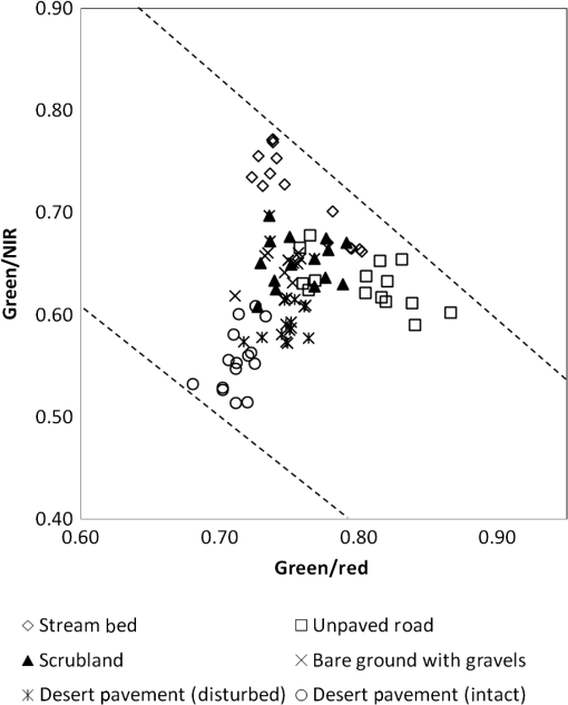
This article [J. Appl. Remote Sens. 9(1), 097694 (23 June 2015)] contained several errors, explained here. In Sec. 2.3.3, in the first sentence of paragraph 2, the text “red/NIR” has been changed to “green/NIR.” Equation (2) has also been changed accordingly. It now reads:

Eq. (2)

ERI=[(1.257×ρgreenρred)]ρgreenρNIR+1.6981.2572+1.

Finally, the same error has been corrected in Fig. 3 and the corresponding caption. The corrected version is shown here:

Fig. 3

Scatter plot of a green/red band ratio versus a green/NIR band ratio by surface type for correspondence to a range of erosion risks.
JARS_9_1_099998_f003.png

The article was corrected online on 30 June 2015.

© 2015 Society of Photo-Optical Instrumentation Engineers (SPIE)
Yuki Hamada and Mark A. Grippo "Errata: Remote-sensing application for facilitating land resource assessment and monitoring for utility-scale solar energy development," Journal of Applied Remote Sensing 9(1), 099998 (16 July 2015). https://doi.org/10.1117/1.JRS.9.099998
Published: 16 July 2015
Lens.org Logo
CITATIONS
Cited by 4 scholarly publications.
Advertisement
Advertisement
RIGHTS & PERMISSIONS
Get copyright permission  Get copyright permission on Copyright Marketplace
KEYWORDS
Remote sensing

Solar energy

Near infrared

Back to Top